000
AXNT20 KNHC 201804
TWDAT
Tropical Weather Discussion
NWS National Hurricane Center Miami FL
1805 UTC Mon May 20 2024
Tropical Weather Discussion for North America, Central America
Gulf of Mexico, Caribbean Sea, northern sections of South
America, and Atlantic Ocean to the African coast from the
Equator to 31N. The following information is based on satellite
imagery, weather observations, radar and meteorological analysis.
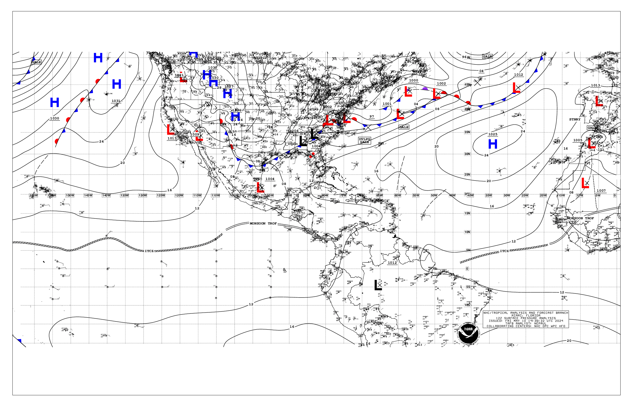
Based on 1200 UTC surface analysis and satellite imagery through
1750 UTC.
...MONSOON TROUGH/ITCZ...
The monsoon trough passes through the NW coastal plains of borders
of Guinea, to 07N19W and to 07N25W and 05N30W. The ITCZ continues
from 05N30W, to 03N40W. Precipitation: scattered moderate to
isolated strong is from: 02N to 04N between 09W and 13W; and from
01N to 07N between 17W and 24W. Isolated moderate to locally
strong is in the remainder of the area that is from 10N southward
from 60W eastward.
...GULF OF MEXICO...
An east-to-west oriented surface trough covers the areas that are
from the coast of Mexico near 24N beyond the Florida west coast
near 26N. Rainshowers are possible within 60 nm on either side of
the surface trough.
Moderate seas are from 23N to 28N from 90W westward. Slight seas
are in the remainder of the Gulf of Mexico. Moderate or slower
seas are in the Gulf of Mexico.
Areas of haze and smoke, from agricultural fires that are in
Mexico, are in most of the western half of the Gulf of Mexico. The
visibilities are being reduced in some cases.
A cold front extends across the northern Florida Peninsula. Ahead
of it, a trough is analyzed along 25N. Scattered showers will
prevail over the Straits of Florida today, supported by a mid to
upper-level trough that extends from the southeastern U.S. coast
southwestward to the southeast Gulf. Gusty winds along with rough
seas will prevail near the convection. Moderate to fresh SE winds
prevail elsewhere, with slight seas. Hazy conditions due to
agricultural fires in Mexico continue across most of the western
Gulf and Bay of Campeche.
...CARIBBEAN SEA...
Strong easterly winds are between 66W and 77W. Moderate E to SE
winds are from 15N northward from 80W westward. Moderate NE winds
are in the SW corner. Moderate to fresh easterly winds are from
66W eastward. Mostly moderate to some rough seas are 12N to 14N
between 72W and 79W. Moderate seas are from 70W westward, except
for the slight seas that are in the Windward Passage. Slight seas
are in from 70W eastward.
Areas of haze and smoke, from agricultural fires that are in
Central America, are in parts of the NW Caribbean Sea, and in the
Gulf of Honduras.
The monsoon trough is along 08N/10N between 75W in Colombia,
beyond 83W in Panama and in Costa Rica. Precipitation: scattered
moderate to strong is from 10N southward in the SW corner of the
Caribbean Sea. Scattered to numerous strong is within 240 nm to
the south of the monsoon trough between 76W and 84W.
An Atlantic surface ridge prevails N of the area. The associated
pressure gradient between the ridge and lower pressure over
northern South America is supporting fresh to strong E winds in
the south-central Caribbean. These winds will shift eastward to
offshore of NW Venezuela through Tue night and diminish early on
Wed. A deep layer trough will dig southward across the western
Caribbean Mon night through Fri, supporting active weather E of
80W Tue through Fri. Fresh to strong E to SE winds will develop in
the central Caribbean Tue and shift eastward through Thu while
diminishing to mostly fresh speeds. Smoke due to agricultural
fires in Central America continues across the Gulf of Honduras,
but continue to thin out.
...ATLANTIC OCEAN...
A cold front passes through 31N70W, 30N76W, passes through 28N/29N
in Florida, to 28N86W in the NE Gulf of Mexico. A surface trough
is about 135 nm to the south of the cold front between 77W and
85W. Precipitation: widely scattered to scattered moderate, to
isolated strong, is from 24N northward between 67W and 83W. This
precipitation is covering parts of: the Straits of Florida, the
Bahamas, and the open waters of the Atlantic Ocean. The 24-hour
rainfall totals in inches, for the period that ended at 19/1200
UTC, are: 0.53 in Freeport in the Bahamas; and 0.11 in the
Bahamas. This information is from the Pan American Temperature and
Precipitation Tables/MIATPTPAN.
Broad surface anticyclonic wind flow spans the rest of the Atlantic
Ocean. A 1024 mb high pressure center is near 33N26W.
Mostly rough seas, and some moderate to rough seas, are from 09N
southward between 10W and 33W. Slight seas are from 60W westward;
and to the north of 12N60W 12N52W 19N41W 21N26W 24N15W. Moderate
seas are in the remainder of the Atlantic Ocean. Fresh to strong
NE winds are from 14N to 30N from 26W eastward. Moderate or slower
winds, with small areas of some fresh winds, cover the remainder
of the Atlantic Ocean.
Scattered showers and thunderstorms prevail across the western
Atlantic W of 70W in the vicinity of a cold front and pre-frontal
trough. The front will move southeastward and stall from near
31N72W to SE Florida late Tue. A trough will develop southeast of
the weakening front and extend into the central Bahamas early on
Wed, and drift eastward through Fri night. Fresh winds and
moderate seas will prevail in the western Atlantic with the
front/trough through midweek, then light to gentle winds and
slight seas are expected through Fri.
$$
mt/al