744
AXNT20 KNHC 132333
TWDAT
Tropical Weather Discussion
NWS National Hurricane Center Miami FL
0005 UTC Tue May 14 2024
Tropical Weather Discussion for North America, Central America
Gulf of Mexico, Caribbean Sea, northern sections of South
America, and Atlantic Ocean to the African coast from the
Equator to 31N. The following information is based on satellite
imagery, weather observations, radar and meteorological analysis.
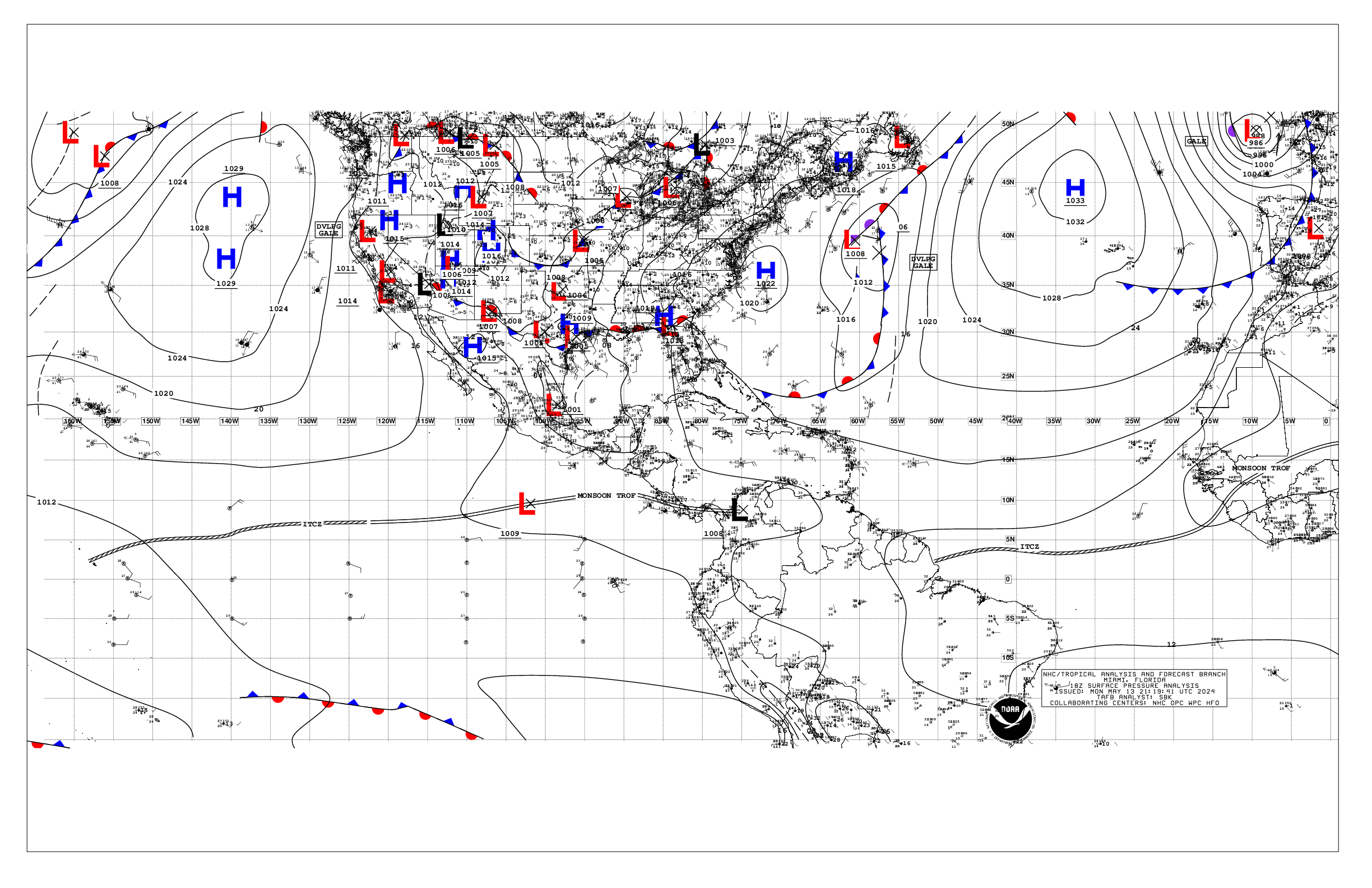
Based on 1800 UTC surface analysis and satellite imagery through
2325 UTC.
...MONSOON TROUGH/ITCZ...
The monsoon trough enters the Atlantic through the coast of
Sierra Leone near 10N14W and continues southwestward to 05N23W.
The ITCZ extends from 05N23W to 03N37W and to 02N51W. Scattered
moderate to isolated strong convection is observed from 02N to 07N
and east of 33W.
...GULF OF MEXICO...
A stationary front over the northern Gulf coast and abundant
moisture result in strong thunderstorms affecting the NW and NE
Gulf waters. The fast-moving squalls are producing gusts to near
gale-force, frequent lightning strikes and heavy downpours. Weak
high pressure dominates the rest of the basin, maintaining fairly
dry weather conditions. Fresh to strong SE winds and seas of 4-6
ft are present off northern Yucatan, especially south of 26N and
between 86W and 90W. Moderate or weaker winds and slight to
moderate seas prevail elsewhere.
Agricultural fires in SE Mexico and Central America, along with
southerly flow over the Gulf of Mexico, result in hazy skies
across the western portion of the basin, especially in the Bay of
Campeche.
For the forecast, an inverted trough is over the western Gulf
with high pressure across the remainder of the basin. The trough
may linger through mid-week. Heavy rainfall and thunderstorms are
expected across the northern Gulf over the next few days. Mainly
moderate to fresh return flow will dominate the basin, pulsing to
strong near the Yucatan Peninsula and Yucatan Channel. Winds may
weaken somewhat during the upcoming weekend as the gradient
relaxes. Meanwhile, haze due to agricultural fires in Mexico
continues across most of the western Gulf and Bay of Campeche.
...CARIBBEAN SEA...
The pressure gradient between a 1022 mb high pressure system off
the Outer Banks and lower pressures in the deep tropics sustain
fresh to strong easterly trade winds in the south-central
Caribbean and Gulf of Honduras. Seas in these waters are 6-9 ft.
Moderate to fresh easterly winds and seas of 4-7 ft are present in
the north-central Caribbean. Elsewhere, moderate or weaker winds
and slight to moderate seas are prevalent. A few showers are noted
in the SW Caribbean, especially within 90 nm of western Panama.
For the forecast, high pressure over the central Atlantic will
support strong to near gale E to SE winds near the Gulf of
Honduras, with fresh to strong winds expected in the south-central
basin through most of the week. Seas will build through the week
as a result of the increasing winds. Gentle to moderate winds are
expected elsewhere through most of the week. Meanwhile, haze due
to agricultural fires in Central America continues across some
areas of the northwestern Caribbean.
...ATLANTIC OCEAN...
A stationary front is analyzed entering the basin near 31N57W and
continues southwestward to 22N67W and then to 24N74W. Scattered
showers are evident on satellite imagery ahead of the frontal
boundary to 52W and north of 26N. Tightening pressure gradient
sustains moderate to fresh southerly winds west of 77W and north
of 26N. The rest of the basin is under the influence of a broad
subtropical ridge over the NE Atlantic. Moderate or weaker winds
and slight to moderate seas prevail elsewhere in the central and
western Atlantic.
Farther east, fresh to strong northerly winds and 7-10 ft seas are
noted north of 15N and east of 22W. In the rest of the eastern
Atlantic, moderate or weaker winds and moderate seas are
prevalent.
For the forecast W of 55W, a stationary front extends from near
31N57W to near the Central Bahamas. Scattered thunderstorms are
ahead of it N of 22N. The front is forecast to progress eastward
while weakening, reaching from near 27N55W to 22N65W by early Tue.
High pressure will build in its wake. Fresh to strong southerly
winds and building seas are forecast offshore N Florida by late
tonight ahead of another possible cold front. That front may reach
from near 31N76W to 27N80W by early Thu, weakening and stalling
from 31N69W to near the northern Bahamas by early Fri. Conditions
around the front should improve by late Fri into the upcoming
weekend.
$$
Delgado