


NHC Offshore Waters Forecasts
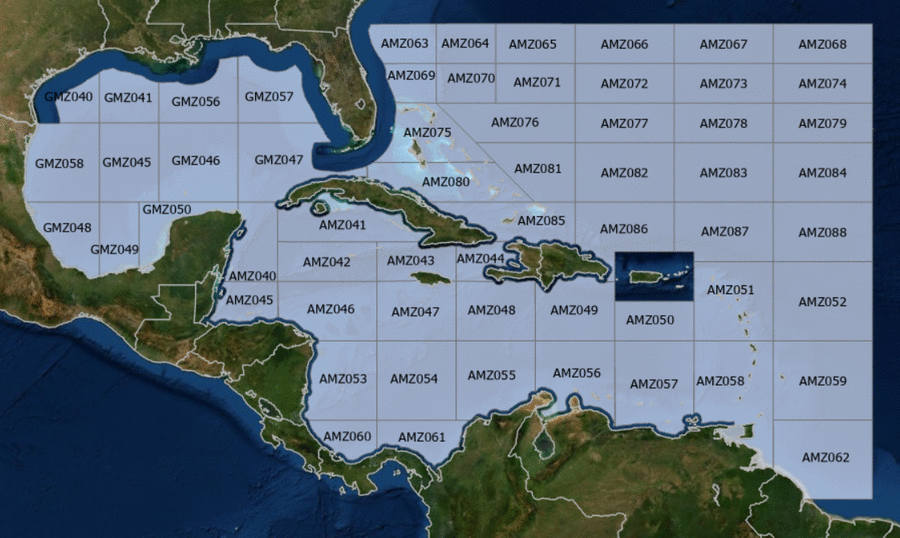
Hover to view popup zone forecast; click a zone to view related text forecast below. Show All Text Below
Southwest Tropical North Atlantic & Caribbean Sea (OFFNT3)
000
FZNT23 KNHC 011447
OFFNT3

Offshore Waters Forecast for the Caribbean Sea and Tropical
N Atlantic
NWS National Hurricane Center Miami, FL
1047 AM EDT Wed May 1 2024

Offshore Waters Forecast for Caribbean Sea, and the Tropical N
Atlantic from 07N to 19N W of 55W.

Seas given as significant wave height, which is the average
height of the highest 1/3 of the waves. Individual waves may be
more than twice the significant wave height.
Synopsis for the Caribbean Sea & Tropical North Atlantic
AMZ001-020300-
Synopsis for Caribbean Sea, and Tropical N Atlantic from 07N to
19N W of 55W
1047 AM EDT Wed May 1 2024

.SYNOPSIS...A 1021 mb high pressure SW of Bermuda and its
associated ridge extending to the Greater Antilles supports
moderate to fresh easterly trade winds over the central and
eastern Caribbean. The ridge is expected to slide eastward and
weaken on Thu, reducing the areal coverage and limiting these
winds to the SE Caribbean by Thu evening. Showers and
thunderstorms currently affecting the Mona and Windward Passages
as well as Hispaniola adjacent waters will amplify tonight into
Thu as a surface trough develops N of Hispaniola. The pressure
gradient between this feature and a weak ridge will also support
moderate to fresh NE winds in the lee Cuba and the Windward
Passage Thu night into Sat night.
AMZ040 Zone Forecast
AMZ040-020300-
Caribbean N of 18N W of 85W including Yucatan Basin-
1047 AM EDT Wed May 1 2024

.TODAY...E winds 10 kt. Seas 2 to 4 ft.
.TONIGHT...NE to E winds 10 to 15 kt. Seas 3 ft or less.
.THU...E winds 10 to 15 kt. Seas 2 to 4 ft.
.THU NIGHT...E winds 10 to 15 kt. Seas 2 to 4 ft.
.FRI...E winds 10 to 15 kt. Seas 2 to 4 ft.
.FRI NIGHT...E winds 10 to 15 kt. Seas 2 to 4 ft.
.SAT...E winds 10 to 15 kt. Seas 3 to 5 ft.
.SAT NIGHT...E winds 10 to 15 kt. Seas 3 to 5 ft.
.SUN...E winds 10 to 15 kt. Seas 3 to 5 ft.
.SUN NIGHT...E winds 10 to 15 kt. Seas 2 to 4 ft.
Forecaster Ramos
AMZ041 Zone Forecast
AMZ041-020300-
Caribbean N of 20N E of 85W-
1047 AM EDT Wed May 1 2024

.TODAY...E winds 10 kt. Seas 3 ft or less.
.TONIGHT...Variable winds less than 5 kt, becoming NE 10 kt late.
Seas 3 ft or less.
.THU...E winds 10 kt. Seas 3 ft or less.
.THU NIGHT...W of 81W, E winds 10 to 15 kt. E of 81W, variable
winds less than 5 kt, becoming NE to E 15 to 20 kt late. Seas
3 ft or less.
.FRI...E winds 10 to 15 kt. Seas 2 to 4 ft.
.FRI NIGHT...E winds 10 to 15 kt W of 81W, and NE to E 15 to
20 kt E of 81W. Seas 2 to 4 ft.
.SAT...E winds 10 to 15 kt. Seas 2 to 4 ft.
.SAT NIGHT...NE to E winds 10 to 15 kt. Seas 2 to 4 ft.
.SUN...E winds 10 to 15 kt. Seas 2 to 4 ft.
.SUN NIGHT...NE to E winds 10 to 15 kt. Seas 2 to 4 ft.
Forecaster Ramos
AMZ042 Zone Forecast
AMZ042-020300-
Caribbean from 18N to 20N between 80W and 85W including Cayman
Basin-
1047 AM EDT Wed May 1 2024

.TODAY...E winds 10 kt. Seas 3 ft or less.
.TONIGHT...W of 82W, NE to E winds 10 kt. E of 82W, variable
winds less than 5 kt, becoming NE 10 kt late. Seas 3 ft
or less.
.THU...NE to E winds 10 kt. Seas 3 ft or less.
.THU NIGHT...NE to E winds 10 kt. Seas 3 ft or less.
.FRI...E winds 10 to 15 kt. Seas 3 ft or less.
.FRI NIGHT...NE to E winds 10 to 15 kt. Seas 3 ft or less.
.SAT...NE to E winds 10 to 15 kt. Seas 2 to 4 ft.
.SAT NIGHT...NE to E winds 10 to 15 kt. Seas 2 to 4 ft.
.SUN...E winds 10 to 15 kt. Seas 2 to 4 ft.
.SUN NIGHT...E winds 10 to 15 kt. Seas 2 to 4 ft.
Forecaster Ramos
AMZ043 Zone Forecast
AMZ043-020300-
Caribbean from 18N to 20N between 76W and 80W-
1047 AM EDT Wed May 1 2024

.TODAY...E winds 10 kt. Seas 2 to 4 ft. Scattered showers and
isolated tstms.
.TONIGHT...E winds 10 kt. Seas 2 to 4 ft. Scattered showers and
isolated tstms.
.THU...E winds 10 kt. Seas 3 ft or less. Scattered showers and
isolated tstms.
.THU NIGHT...W of 78W, variable winds less than 5 kt, becoming NE
to E 10 to 15 kt late. E of 78W, NE to E winds 10 kt.
Seas 3 ft or less.
.FRI...NE to E winds 10 to 15 kt. Seas 2 to 4 ft.
.FRI NIGHT...NE to E winds 10 to 15 kt. Seas 2 to 4 ft.
.SAT...NE to E winds 10 to 15 kt. Seas 3 to 5 ft.
.SAT NIGHT...E winds 10 to 15 kt. Seas 3 to 5 ft.
.SUN...E winds 10 to 15 kt. Seas 2 to 4 ft.
.SUN NIGHT...E winds 10 to 15 kt. Seas 2 to 4 ft.
Forecaster Ramos
AMZ044 Zone Forecast
AMZ044-020300-
Caribbean approaches to the Windward Passage-
1047 AM EDT Wed May 1 2024

.TODAY...Variable winds less than 5 kt in the Gulf of Gonave, and
E to SE 10 to 15 kt elsewhere. Seas 3 to 5 ft. Scattered showers
and isolated tstms.
.TONIGHT...Variable winds less than 5 kt in the Gulf of Gonave,
and NE 10 kt elsewhere. Seas 3 to 5 ft. Scattered showers and
isolated tstms.
.THU...Variable winds less than 5 kt in the Gulf of Gonave, and
NE to E 10 to 15 kt elsewhere. Seas 2 to 4 ft. Scattered showers
and isolated tstms.
.THU NIGHT...In the Gulf of Gonave, NW to N winds 10 kt in the
evening, becoming variable less than 5 kt. Elsewhere, NE winds
10 to 15 kt. Seas 3 ft or less.
.FRI...In the Gulf of Gonave, variable winds less than 5 kt,
becoming NW to N 10 kt in the afternoon. Elsewhere, NE winds
10 to 15 kt. Seas 3 ft or less.
.FRI NIGHT...NE winds 10 to 15 kt in the Gulf of Gonave, and NE
15 to 20 kt elsewhere. Seas 3 to 5 ft.
.SAT...In the Gulf of Gonave, NE to E winds 10 kt in the morning,
becoming variable less than 5 kt. Elsewhere, NE to E winds 10 to
15 kt. Seas 3 to 5 ft.
.SAT NIGHT...Variable winds less than 5 kt in the Gulf of Gonave,
and NE to E 15 to 20 kt elsewhere. Seas 3 to 5 ft.
.SUN...In the Gulf of Gonave, E to SE winds 10 kt in the morning,
becoming variable less than 5 kt. Elsewhere, E winds 10 to 15 kt.
Seas 3 to 5 ft.
.SUN NIGHT...In the Gulf of Gonave, variable winds less than
5 kt. Seas 3 ft or less. Elsewhere, E winds 10 to 15 kt. Seas
3 to 5 ft.
Forecaster Ramos
AMZ045 Zone Forecast
AMZ045-020300-
S of 18N W of 85W including Gulf of Honduras-
1047 AM EDT Wed May 1 2024

.TODAY...E winds 10 to 15 kt. Seas 2 to 4 ft.
.TONIGHT...NE to E winds 10 to 15 kt. Seas 3 ft or less.
.THU...E winds 10 to 15 kt. Seas 3 ft or less.
.THU NIGHT...NE to E winds 10 to 15 kt. Seas 3 ft or less.
.FRI...E winds 10 to 15 kt. Seas 3 ft or less.
.FRI NIGHT...E winds 10 to 15 kt. Seas 3 ft or less.
.SAT...E winds 10 to 15 kt. Seas 3 ft or less.
.SAT NIGHT...E winds 15 kt. Seas 2 to 4 ft.
.SUN...E winds 10 to 15 kt. Seas 2 to 4 ft.
.SUN NIGHT...E winds 10 to 15 kt. Seas 2 to 4 ft.
Forecaster Ramos
AMZ046 Zone Forecast
AMZ046-020300-
Caribbean from 15N to 18N between 80W and 85W-
1047 AM EDT Wed May 1 2024

.TODAY...NE to E winds 10 kt. Seas 3 ft or less.
.TONIGHT...W of 82W, NE winds 10 to 15 kt. E of 82W, variable
winds less than 5 kt, becoming NE to E 10 kt late. Seas
3 ft or less.
.THU...NE to E winds 10 kt. Seas 3 ft or less.
.THU NIGHT...W of 82W, NE to E winds 10 kt. E of 82W, variable
winds less than 5 kt, becoming NE to E 10 kt late. Seas
3 ft or less.
.FRI...E winds 10 kt. Seas 3 ft or less W of 82W, and 3 ft or
less E of 82W.
.FRI NIGHT...NE to E winds 10 to 15 kt. Seas 3 ft or less.
.SAT...E winds 10 kt. Seas 3 ft or less.
.SAT NIGHT...NE to E winds 10 to 15 kt. Seas 3 ft or less.
.SUN...NE to E winds 10 kt. Seas 3 ft or less.
.SUN NIGHT...E winds 10 to 15 kt. Seas 3 ft or less.
Forecaster Ramos
AMZ047 Zone Forecast
AMZ047-020300-
Caribbean from 15N to 18N between 76W and 80W-
1047 AM EDT Wed May 1 2024

.TODAY...E winds 10 to 15 kt. Seas 3 to 5 ft. Scattered showers
and isolated tstms.
.TONIGHT...E winds 10 kt. Seas 3 to 5 ft.
.THU...E winds 10 kt. Seas 2 to 4 ft.
.THU NIGHT...NE to E winds 10 kt. Seas 2 to 4 ft.
.FRI...NE to E winds 10 kt. Seas 2 to 4 ft.
.FRI NIGHT...NE to E winds 10 to 15 kt. Seas 2 to 4 ft.
.SAT...NE to E winds 10 to 15 kt. Seas 2 to 4 ft.
.SAT NIGHT...NE to E winds 10 to 15 kt. Seas 2 to 4 ft.
.SUN...E winds 10 to 15 kt. Seas 2 to 4 ft.
.SUN NIGHT...E winds 10 to 15 kt. Seas 2 to 4 ft.
Forecaster Ramos
AMZ048 Zone Forecast
AMZ048-020300-
Caribbean from 15N to 18N between 72W and 76W-
1047 AM EDT Wed May 1 2024

.TODAY...E winds 15 to 20 kt. Seas 4 to 6 ft.
.TONIGHT...E winds 10 to 15 kt. Seas 3 to 5 ft. Scattered showers
and isolated tstms.
.THU...E winds 10 to 15 kt. Seas 3 to 5 ft.
.THU NIGHT...NE to E winds 10 kt. Seas 3 to 5 ft. Scattered
showers and isolated tstms.
.FRI...NE to E winds 10 kt. Seas 2 to 4 ft.
.FRI NIGHT...NE to E winds 10 kt. Seas 2 to 4 ft.
.SAT...E winds 10 to 15 kt. Seas 2 to 4 ft.
.SAT NIGHT...E winds 10 to 15 kt. Seas 2 to 4 ft.
.SUN...E winds 10 to 15 kt S of 17N, and E 15 to 20 kt N of 17N.
Seas 3 to 5 ft.
.SUN NIGHT...E winds 15 kt. Seas 4 to 6 ft.
Forecaster Ramos
AMZ049 Zone Forecast
AMZ049-020300-
Caribbean N of 15N between 68W and 72W-
1047 AM EDT Wed May 1 2024

.TODAY...E winds 15 kt. Seas 4 to 6 ft.
.TONIGHT...E winds 10 to 15 kt. Seas 4 to 6 ft.
.THU...E to SE winds 10 to 15 kt. Seas 4 to 6 ft.
.THU NIGHT...E winds 10 kt. Seas 3 to 5 ft. Scattered showers and
isolated tstms.
.FRI...E winds 10 kt. Seas 3 to 5 ft.
.FRI NIGHT...E winds 10 to 15 kt. Seas 2 to 4 ft.
.SAT...E winds 10 to 15 kt. Seas 2 to 4 ft.
.SAT NIGHT...E winds 15 to 20 kt W of 70W, and NE to E 10 to
15 kt E of 70W. Seas 2 to 4 ft.
.SUN...E winds 15 to 20 kt. Seas 4 to 6 ft.
.SUN NIGHT...E winds 15 to 20 kt. Seas 4 to 6 ft.
Forecaster Ramos
AMZ050 Zone Forecast
AMZ050-020300-
Caribbean N of 15N between 64W and 68W-
1047 AM EDT Wed May 1 2024

.TODAY...E to SE winds 15 kt. Seas 4 to 6 ft.
.TONIGHT...E winds 15 to 20 kt. Seas 4 to 6 ft.
.THU...E to SE winds 15 to 20 kt. Seas 4 to 6 ft.
.THU NIGHT...E to SE winds 10 to 15 kt. Seas 3 to 5 ft. Isolated
tstms.
.FRI...E to SE winds 10 to 15 kt. Seas 3 to 5 ft.
.FRI NIGHT...E winds 10 to 15 kt. Seas 3 to 5 ft.
.SAT...E to SE winds 10 to 15 kt. Seas 2 to 4 ft.
.SAT NIGHT...E winds 10 to 15 kt. Seas 2 to 4 ft.
.SUN...E winds 10 to 15 kt. Seas 3 to 5 ft.
.SUN NIGHT...NE to E winds 15 to 20 kt. Seas 3 to 5 ft.
Forecaster Ramos
AMZ051 Zone Forecast
AMZ051-020300-
Offshore Waters Leeward Islands-
1047 AM EDT Wed May 1 2024

.TODAY...E winds 10 to 15 kt. Seas 6 to 8 ft in N swell.
.TONIGHT...E winds 15 kt. Seas 5 to 7 ft in N to NE swell.
.THU...E to SE winds 15 to 20 kt. Seas 5 to 7 ft.
.THU NIGHT...E to SE winds 10 to 15 kt. Seas 5 to 7 ft in E
swell.
.FRI...SE winds 10 to 15 kt. Seas 5 to 7 ft in NE to E swell.
.FRI NIGHT...SE winds 10 kt. Seas 4 to 6 ft in N to NE swell.
.SAT...SE winds 10 to 15 kt. Seas 3 to 5 ft.
.SAT NIGHT...NE to E winds 10 kt. Seas 3 to 5 ft.
.SUN...NE to E winds 10 kt. Seas 3 to 5 ft.
.SUN NIGHT...NE to E winds 10 to 15 kt. Seas 3 to 5 ft.
Forecaster Ramos
AMZ052 Zone Forecast
AMZ052-020300-
Tropical N Atlantic from 15N to 19N between 55W and 60W-
1047 AM EDT Wed May 1 2024

.TODAY...E winds 15 kt. Seas 6 to 8 ft in N swell.
.TONIGHT...E winds 15 kt. Seas 5 to 7 ft in N swell.
.THU...E winds 15 kt. Seas 5 to 7 ft in N swell.
.THU NIGHT...E to SE winds 15 kt. Seas 5 to 7 ft in NE swell.
.FRI...SE winds 10 to 15 kt. Seas 4 to 6 ft.
.FRI NIGHT...SE winds 10 kt. Seas 4 to 6 ft in N swell.
.SAT...SE to S winds 10 kt. Seas 4 to 6 ft in N swell.
.SAT NIGHT...E to SE winds 10 kt S of 17N, and variable less than
5 kt N of 17N. Seas 4 to 6 ft in N swell.
.SUN...E winds 10 kt S of 17N, and variable less than 5 kt N of
17N. Seas 3 to 5 ft.
.SUN NIGHT...NE winds 10 kt. Seas 3 to 5 ft.
Forecaster Ramos
AMZ053 Zone Forecast
AMZ053-020300-
W Central Caribbean from 11N to 15N W of 80W-
1047 AM EDT Wed May 1 2024

.TODAY...NE to E winds 10 kt late in the morning, becoming
variable less than 5 kt. Seas 2 to 4 ft.
.TONIGHT...NE winds 10 kt. Seas 2 to 4 ft.
.THU...In the reefs, variable winds less than 5 kt. In the open
waters, NE to E winds 10 kt in the morning, becoming variable
less than 5 kt. Seas 2 to 4 ft.
.THU NIGHT...In the reefs, NE to E winds 10 kt. In the open
waters, variable winds less than 5 kt, becoming NE to E 10 kt
late. Seas 3 ft or less.
.FRI...Variable winds less than 5 kt. Seas 3 ft or less in NE to
E swell.
.FRI NIGHT...NE to E winds 10 kt. Seas 3 ft or less.
.SAT...In the reefs, variable winds less than 5 kt. In the open
waters, NE to E winds 10 kt in the morning, becoming variable
less than 5 kt. Seas 3 ft or less.
.SAT NIGHT...NE to E winds 10 kt. Seas 3 ft or less.
.SUN...In the reefs, variable winds less than 5 kt. In the open
waters, E winds 10 kt in the morning, becoming variable less than
5 kt. Seas 3 ft or less.
.SUN NIGHT...NE to E winds 10 kt. Seas 3 ft or less.
Forecaster Ramos
AMZ054 Zone Forecast
AMZ054-020300-
Caribbean from 11N to 15N between 76W and 80W-
1047 AM EDT Wed May 1 2024

.TODAY...NE to E winds 10 kt W of 78W, and NE to E 10 to 15 kt E
of 78W. Seas 4 to 6 ft in NE to E swell.
.TONIGHT...NE winds 10 to 15 kt. Seas 3 to 5 ft.
.THU...NE to E winds 10 to 15 kt. Seas 3 to 5 ft.
.THU NIGHT...N to NE winds 10 kt. Seas 2 to 4 ft.
.FRI...NE winds 10 kt. Seas 3 ft or less.
.FRI NIGHT...NE winds 10 kt. Seas 3 ft or less.
.SAT...NE winds 10 kt. Seas 3 ft or less.
.SAT NIGHT...NE winds 10 kt. Seas 3 ft or less.
.SUN...NE to E winds 10 kt. Seas 3 ft or less.
.SUN NIGHT...NE to E winds 10 kt. Seas 3 ft or less.
Forecaster Ramos
AMZ055 Zone Forecast
AMZ055-020300-
Caribbean from 11N to 15N between 72W and 76W including Colombia
Basin-
1047 AM EDT Wed May 1 2024

.TODAY...E winds 15 to 20 kt. Seas 4 to 6 ft.
.TONIGHT...NE to E winds 15 to 20 kt. Seas 5 to 7 ft.
.THU...E winds 10 to 15 kt. Seas 4 to 6 ft.
.THU NIGHT...NE to E winds 10 kt. Seas 3 to 5 ft. Scattered
showers and isolated tstms.
.FRI...NE to E winds 10 kt. Seas 2 to 4 ft.
.FRI NIGHT...NE winds 10 kt. Seas 2 to 4 ft.
.SAT...S of 13N, E winds 10 kt in the morning, becoming variable
less than 5 kt. N of 13N, E winds 10 kt. Seas 3 ft or less.
.SAT NIGHT...NE to E winds 10 kt. Seas 2 to 4 ft.
.SUN...NE to E winds 10 to 15 kt. Seas 2 to 4 ft.
.SUN NIGHT...NE to E winds 10 to 15 kt S of 13N, and E 15 to
20 kt N of 13N. Seas 4 to 6 ft.
Forecaster Ramos
AMZ056 Zone Forecast
AMZ056-020300-
Caribbean S of 15N between 68W and 72W including Gulf of
Venezuela-
1047 AM EDT Wed May 1 2024

.TODAY...E winds 15 to 20 kt. Seas 4 to 6 ft.
.TONIGHT...E winds 15 to 20 kt. Seas 4 to 6 ft.
.THU...E winds 15 to 20 kt. Seas 4 to 6 ft.
.THU NIGHT...E winds 10 to 15 kt. Seas 3 to 5 ft. Scattered
showers and isolated tstms.
.FRI...E to SE winds 10 to 15 kt. Seas 3 to 5 ft.
.FRI NIGHT...NE to E winds 10 to 15 kt. Seas 3 to 5 ft.
.SAT...E to SE winds 10 to 15 kt. Seas 3 to 5 ft.
.SAT NIGHT...E winds 10 to 15 kt. Seas 3 to 5 ft.
.SUN...E winds 10 to 15 kt S of 13N, and E 15 to 20 kt N of 13N.
Seas 4 to 6 ft.
.SUN NIGHT...E winds 15 to 20 kt. Seas 4 to 6 ft.
Forecaster Ramos
AMZ057 Zone Forecast
AMZ057-020300-
Caribbean S of 15N between 64W and 68W including Venezuela Basin-
1047 AM EDT Wed May 1 2024

.TODAY...E winds 15 to 20 kt. Seas 3 to 5 ft.
.TONIGHT...E winds 15 to 20 kt. Seas 4 to 6 ft.
.THU...E winds 15 to 20 kt. Seas 4 to 6 ft.
.THU NIGHT...E winds 15 to 20 kt. Seas 4 to 6 ft.
.FRI...E to SE winds 15 to 20 kt. Seas 4 to 6 ft.
.FRI NIGHT...E winds 15 to 20 kt. Seas 3 to 5 ft.
.SAT...E to SE winds 15 to 20 kt. Seas 4 to 6 ft.
.SAT NIGHT...E winds 15 to 20 kt. Seas 3 to 5 ft.
.SUN...E winds 15 to 20 kt. Seas 3 to 5 ft.
.SUN NIGHT...E winds 15 to 20 kt. Seas 3 to 5 ft.
Forecaster Ramos
AMZ058 Zone Forecast
AMZ058-020300-
Offshore Waters Windward Islands including Trinidad and Tobago-
1047 AM EDT Wed May 1 2024

.TODAY...E winds 10 to 15 kt. Seas 5 to 7 ft in N to NE swell.
.TONIGHT...E winds 15 to 20 kt in the Caribbean, and E 10 to
15 kt in the Atlc. Seas 5 to 7 ft in N to NE swell.
.THU...E to SE winds 15 to 20 kt in the Caribbean, and E 10 to
15 kt in the Atlc. Seas 5 to 7 ft in NE to E swell.
.THU NIGHT...E to SE winds 15 to 20 kt in the Caribbean, and E
10 to 15 kt in the Atlc. Seas 5 to 7 ft in E swell.
.FRI...E to SE winds 15 to 20 kt in the Caribbean, and E to SE
10 to 15 kt in the Atlc. Seas 5 to 7 ft in E swell.
.FRI NIGHT...E to SE winds 15 to 20 kt in the Caribbean, and E
10 to 15 kt in the Atlc. Seas 4 to 6 ft.
.SAT...E to SE winds 15 to 20 kt in the Caribbean, and E 10 to
15 kt in the Atlc. Seas 4 to 6 ft.
.SAT NIGHT...E winds 15 to 20 kt in the Caribbean, and E 10 to
15 kt in the Atlc. Seas 4 to 6 ft.
.SUN...E winds 10 to 15 kt. Seas 4 to 6 ft.
.SUN NIGHT...NE to E winds 10 to 15 kt. Seas 4 to 6 ft.
Forecaster Ramos
AMZ059 Zone Forecast
AMZ059-020300-
Tropical N Atlantic from 11N and 15N between 55W and 60W-
1047 AM EDT Wed May 1 2024

.TODAY...E winds 10 to 15 kt. Seas 5 to 7 ft in N swell.
.TONIGHT...E winds 15 kt. Seas 5 to 7 ft in N swell. Scattered
showers and isolated tstms.
.THU...E winds 15 kt. Seas 6 to 8 ft in N swell.
.THU NIGHT...E winds 15 kt. Seas 5 to 7 ft in E swell.
.FRI...E to SE winds 15 kt. Seas 5 to 7 ft in E to SE swell.
.FRI NIGHT...E to SE winds 10 to 15 kt. Seas 5 to 7 ft in E to SE
swell.
.SAT...E to SE winds 10 to 15 kt. Seas 5 to 7 ft in E swell.
.SAT NIGHT...E winds 10 to 15 kt. Seas 5 to 7 ft in NE to E
swell.
.SUN...E winds 10 to 15 kt. Seas 5 to 7 ft in E swell.
.SUN NIGHT...NE to E winds 10 to 15 kt. Seas 4 to 6 ft.
Forecaster Ramos
AMZ060 Zone Forecast
AMZ060-020300-
SW Caribbean S of 11N W of 80W-
1047 AM EDT Wed May 1 2024

.TODAY...NE winds 10 kt. Seas 2 to 4 ft.
.TONIGHT...S of 10N, variable winds less than 5 kt, becoming NW
to N 10 kt late. N of 10N, N to NE winds 10 kt. Seas
2 to 4 ft.
.THU...Variable winds less than 5 kt. Seas 2 to 4 ft in NE swell.
.THU NIGHT...S of 10N, variable less than 5 kt. Variable winds
less than 5 kt in the evening. N of 10N, NE to E winds 10 kt
late. Seas 3 ft or less in NE swell.
.FRI...Variable winds less than 5 kt. Seas 3 ft or less in NE
swell.
.FRI NIGHT...S of 10N, N winds 10 kt in the evening, becoming
variable less than 5 kt. N of 10N, variable winds less than 5 kt,
becoming NE to E 10 kt late. Seas 3 ft or less.
.SAT...Variable winds less than 5 kt. Seas 3 ft or less.
.SAT NIGHT...Variable winds less than 5 kt. Seas 3 ft or less.
.SUN...Variable winds less than 5 kt. Seas 3 ft or less.
.SUN NIGHT...S of 10N, variable winds less than 5 kt. N of 10N, N
to NE winds 10 kt in the evening, becoming variable less than
5 kt. Seas 3 ft or less.
Forecaster Ramos
AMZ061 Zone Forecast
AMZ061-020300-
SW Caribbean S of 11N E of 80W including the approaches to the
Panama Canal-
1047 AM EDT Wed May 1 2024

.TODAY...N to NE winds 10 kt. Seas 4 to 6 ft in NE swell.
.TONIGHT...N winds 10 to 15 kt. Seas 3 to 5 ft. Scattered showers
and isolated tstms.
.THU...N winds 10 kt. Seas 2 to 4 ft.
.THU NIGHT...NW to N winds 10 kt. Seas 2 to 4 ft. Scattered
showers and isolated tstms.
.FRI...W to NW winds 10 kt S of 10N, and variable less than 5 kt
N of 10N. Seas 3 ft or less.
.FRI NIGHT...NW to N winds 10 kt. Seas 3 ft or less.
.SAT...Variable winds less than 5 kt. Seas 3 ft or less.
.SAT NIGHT...S of 10N, NW to N winds 10 kt in the evening,
becoming variable less than 5 kt. N of 10N, variable winds less
than 5 kt. Seas 3 ft or less.
.SUN...S of 10N, variable winds less than 5 kt, becoming NW to N
10 kt in the afternoon. N of 10N, variable winds less than 5 kt.
Seas 3 ft or less.
.SUN NIGHT...N winds 10 kt in the evening, becoming variable less
than 5 kt. Seas 3 ft or less.
Forecaster Ramos
AMZ062 Zone Forecast
AMZ062-020300-
Tropical N Atlantic from 7N and 11N between 55W and 60W-
1047 AM EDT Wed May 1 2024

.TODAY...E winds 10 to 15 kt. Seas 4 to 6 ft.
.TONIGHT...E winds 15 kt. Seas 5 to 7 ft in N swell.
.THU...E winds 10 to 15 kt. Seas 6 to 8 ft in N swell.
.THU NIGHT...E winds 15 kt. Seas 5 to 7 ft in E swell.
.FRI...E winds 15 kt. Seas 5 to 7 ft in E swell.
.FRI NIGHT...E winds 15 kt. Seas 5 to 7 ft in E swell.
.SAT...E winds 15 kt. Seas 5 to 7 ft in E swell.
.SAT NIGHT...E winds 15 kt. Seas 5 to 7 ft in E swell.
.SUN...E winds 10 to 15 kt. Seas 5 to 7 ft in E swell.
.SUN NIGHT...NE to E winds 15 kt. Seas 5 to 7 ft in E swell.
Forecaster Ramos
Southwest North Atlantic (OFFNT5)
000
FZNT25 KNHC 011512
OFFNT5

Offshore Waters Forecast for the SW N Atlantic including the
Bahamas
NWS National Hurricane Center Miami, FL
1112 AM EDT Wed May 1 2024

Offshore Waters Forecast for the SW N Atlantic from 19N to 31N W
of 55W including Bahamas.

Seas given as significant wave height, which is the average
height of the highest 1/3 of the waves. Individual waves may be
more than twice the significant wave height.
Synopsis for the Southwest Atlantic
AMZ101-020315-
Synopsis for the SW N Atlantic including the Bahamas
1112 AM EDT Wed May 1 2024

.SYNOPSIS...A 1021 mb high pressure SW of Bermuda and its
associated ridge extends across the SW Atlantic and supports
moderate to fresh easterly winds S of 25N, including the
approaches to the Windward Passage. The ridge is expected to
slide eastward and weaken on Thu while a surface trough develops
just N of Hispaniola. The pressure gradient between the ridge and
the trough will support E-SE winds of the same magnitude E of the
trough and NE-E moderate to fresh winds W of the trough. The
trough will also amplify the area of showers and tstms currently
affecting the central Bahamas and the Great Bahama Bank. The
trough is forecast to become a weak low, which will track NE Fri
through Sat, and open back into a trough while exiting the area
Sat afternoon. Locally strong and gusty winds are possible to
develop in the northern semicircle of the low within this period.
AMZ063 Zone Forecast
AMZ063-020315-
Atlantic from 29N to 31N W of 77W-
1112 AM EDT Wed May 1 2024

.TODAY...Variable winds less than 5 kt. Seas 3 to 5 ft in NE to E
swell.
.TONIGHT...W of 79W, SE winds 10 kt. E of 79W, variable winds
less than 5 kt, becoming SE to S 10 kt late. Seas 2 to
4 ft in NE to E swell.
.THU...Variable winds less than 5 kt, becoming E 10 kt in the
afternoon. Seas 3 ft or less.
.THU NIGHT...E to SE winds 10 kt. Seas 3 ft or less.
.FRI...E to SE winds 10 kt. Seas 3 ft or less.
.FRI NIGHT...E to SE winds 10 kt. Seas 3 ft or less.
.SAT...E to SE winds 10 kt. Seas 2 to 4 ft.
.SAT NIGHT...SE winds 10 to 15 kt. Seas 2 to 4 ft.
.SUN...SE winds 10 to 15 kt. Seas 2 to 4 ft.
.SUN NIGHT...SE winds 10 to 15 kt. Seas 3 to 5 ft.
Forecaster Ramos
AMZ064 Zone Forecast
AMZ064-020315-
Atlantic from 29N to 31N between 74W and 77W-
1112 AM EDT Wed May 1 2024

.TODAY...SE to S winds 10 kt. Seas 3 to 5 ft.
.TONIGHT...W of 75W, SE to S winds 10 kt. E of 75W, SE to S winds
10 kt in the evening, becoming variable less than 5 kt. Seas 2 to
4 ft.
.THU...Variable winds less than 5 kt, becoming E 10 kt in the
afternoon. Seas 3 ft or less.
.THU NIGHT...E winds 10 kt. Seas 3 ft or less.
.FRI...E winds 10 kt. Seas 2 to 4 ft.
.FRI NIGHT...E winds 10 kt. Seas 2 to 4 ft.
.SAT...E winds 10 kt. Seas 2 to 4 ft.
.SAT NIGHT...E to SE winds 10 to 15 kt. Seas 2 to 4 ft.
.SUN...E to SE winds 10 to 15 kt. Seas 3 to 5 ft.
.SUN NIGHT...E to SE winds 10 to 15 kt. Seas 3 to 5 ft.
Forecaster Ramos
AMZ065 Zone Forecast
AMZ065-020315-
Atlantic from 29N to 31N between 70W and 74W-
1112 AM EDT Wed May 1 2024

.TODAY...SE to S winds 10 kt. Seas 3 to 5 ft.
.TONIGHT...SE to S winds 10 kt in the evening, becoming variable
less than 5 kt. Seas 2 to 4 ft.
.THU...E winds 10 kt. Seas 3 ft or less.
.THU NIGHT...E winds 10 kt. Seas 3 ft or less.
.FRI...NE to E winds 10 kt. Seas 2 to 4 ft.
.FRI NIGHT...NE winds 10 kt. Seas 2 to 4 ft.
.SAT...NE winds 10 kt. Seas 2 to 4 ft.
.SAT NIGHT...NE to E winds 10 to 15 kt. Seas 3 to 5 ft.
.SUN...NE to E winds 10 kt. Seas 3 to 5 ft.
.SUN NIGHT...E winds 10 kt. Seas 3 to 5 ft.
Forecaster Ramos
AMZ066 Zone Forecast
AMZ066-020315-
Atlantic from 29N to 31N between 65W and 70W-
1112 AM EDT Wed May 1 2024

.TODAY...E to SE winds 10 kt W of 67W, and variable less than
5 kt E of 67W. Seas 2 to 4 ft.
.TONIGHT...W of 67W, E to SE winds 10 kt. E of 67W, variable
winds less than 5 kt, becoming E to SE 10 kt late. Seas
2 to 4 ft.
.THU...E to SE winds 10 kt. Seas 2 to 4 ft.
.THU NIGHT...W of 67W, E winds 10 kt. E of 67W, E winds 10 kt in
the evening, becoming variable less than 5 kt. Seas 2 to 4 ft.
.FRI...N to NE winds 10 kt. Seas 2 to 4 ft.
.FRI NIGHT...N winds 10 to 15 kt. Seas 3 ft or less.
.SAT...N to NE winds 10 to 15 kt. Seas 3 to 5 ft.
.SAT NIGHT...N to NE winds 10 to 15 kt. Seas 4 to 6 ft.
.SUN...NE winds 10 kt. Seas 4 to 6 ft in N to NE swell.
.SUN NIGHT...NE to E winds 10 kt. Seas 3 to 5 ft.
Forecaster Ramos
AMZ067 Zone Forecast
AMZ067-020315-
Atlantic from 29N to 31N between 60W and 65W-
1112 AM EDT Wed May 1 2024

.TODAY...Variable winds less than 5 kt. Seas 4 to 6 ft in N to NE
swell.
.TONIGHT...Variable winds less than 5 kt. Seas 4 to 6 ft in N to
NE swell.
.THU...Variable winds less than 5 kt. Seas 4 to 6 ft in N to NE
swell.
.THU NIGHT...Variable winds less than 5 kt. Seas 3 to 5 ft in N
to NE swell.
.FRI...W of 62W, N to NE winds 10 kt in the morning, becoming
variable less than 5 kt. E of 62W, variable winds less than 5 kt.
Seas 2 to 4 ft in N swell.
.FRI NIGHT...NW winds 10 to 15 kt. Seas 2 to 4 ft.
.SAT...NW to N winds 10 to 15 kt. Seas 4 to 6 ft.
.SAT NIGHT...N winds 10 to 15 kt. Seas 4 to 6 ft.
.SUN...N to NE winds 10 to 15 kt. Seas 4 to 6 ft.
.SUN NIGHT...NE winds 10 to 15 kt. Seas 5 to 7 ft in N to NE
swell.
Forecaster Ramos
AMZ068 Zone Forecast
AMZ068-020315-
Atlantic from 29N to 31N between 55W and 60W-
1112 AM EDT Wed May 1 2024

.TODAY...Variable winds less than 5 kt W of 57W, and NW to N
10 kt E of 57W. Seas 6 to 8 ft in N swell.
.TONIGHT...W of 57W, variable winds less than 5 kt in the
evening. Variable winds less than 5 kt late. E of 57W,
N winds 10 kt in the evening. Seas 6 to 9 ft in N swell.
.THU...Variable winds less than 5 kt. Seas 5 to 7 ft in N swell.
.THU NIGHT...W of 57W, variable winds less than 5 kt. E of 57W, W
to NW winds 10 kt, shifting to SW late. Seas 4 to 6 ft
in N swell.
.FRI...W of 57W, variable less than 5 kt. Variable winds less
than 5 kt in the morning. E of 57W, S to SW winds 10 kt in the
afternoon. Seas 3 to 5 ft in NW to N swell.
.FRI NIGHT...SW to W winds 10 to 15 kt. Seas 3 to 5 ft.
.SAT...W to NW winds 10 to 15 kt. Seas 3 to 5 ft.
.SAT NIGHT...NW to N winds 10 to 15 kt. Seas 4 to 6 ft.
.SUN...N winds 15 to 20 kt. Seas 5 to 7 ft.
.SUN NIGHT...N winds 10 to 15 kt. Seas 6 to 8 ft in N to NE
swell.
Forecaster Ramos
AMZ069 Zone Forecast
AMZ069-020315-
Atlantic from 27N to 29N W of 77W-
1112 AM EDT Wed May 1 2024

.TODAY...Variable winds less than 5 kt. Seas 3 to 5 ft in NE
swell.
.TONIGHT...E to SE winds 10 kt. Seas 3 to 5 ft.
.THU...Variable winds less than 5 kt, becoming E 10 kt in the
afternoon. Seas 2 to 4 ft.
.THU NIGHT...E winds 10 kt. Seas 2 to 4 ft.
.FRI...E winds 10 kt. Seas 2 to 4 ft.
.FRI NIGHT...E winds 10 to 15 kt. Seas 2 to 4 ft.
.SAT...E to SE winds 10 to 15 kt. Seas 3 to 5 ft.
.SAT NIGHT...E to SE winds 10 to 15 kt. Seas 3 to 5 ft.
.SUN...E to SE winds 10 to 15 kt. Seas 3 to 5 ft.
.SUN NIGHT...E to SE winds 15 kt. Seas 3 to 5 ft.
Forecaster Ramos
AMZ070 Zone Forecast
AMZ070-020315-
Atlantic from 27N to 29N between 74W and 77W-
1112 AM EDT Wed May 1 2024

.TODAY...SE winds 10 kt. Seas 4 to 6 ft in NE swell. Scattered
showers and isolated tstms.
.TONIGHT...SE winds 10 kt. Seas 3 to 5 ft.
.THU...E winds 10 kt. Seas 2 to 4 ft.
.THU NIGHT...E winds 10 kt. Seas 2 to 4 ft.
.FRI...NE to E winds 10 to 15 kt. Seas 2 to 4 ft.
.FRI NIGHT...E winds 10 to 15 kt. Seas 3 to 5 ft.
.SAT...E winds 10 to 15 kt. Seas 3 to 5 ft.
.SAT NIGHT...E winds 10 to 15 kt. Seas 3 to 5 ft.
.SUN...E winds 10 to 15 kt. Seas 3 to 5 ft.
.SUN NIGHT...E to SE winds 10 to 15 kt. Seas 3 to 5 ft.
Forecaster Ramos
AMZ071 Zone Forecast
AMZ071-020315-
Atlantic from 27N to 29N between 70W and 74W-
1112 AM EDT Wed May 1 2024

.TODAY...SE winds 10 kt. Seas 3 to 5 ft.
.TONIGHT...SE winds 10 kt. Seas 3 to 5 ft.
.THU...E winds 10 kt. Seas 2 to 4 ft.
.THU NIGHT...E winds 10 kt. Seas 2 to 4 ft.
.FRI...NE to E winds 10 to 15 kt. Seas 3 to 5 ft.
.FRI NIGHT...NE to E winds 10 to 15 kt. Seas 3 to 5 ft.
.SAT...NE to E winds 10 to 15 kt. Seas 3 to 5 ft.
.SAT NIGHT...NE to E winds 10 to 15 kt. Seas 3 to 5 ft.
.SUN...NE to E winds 10 to 15 kt. Seas 3 to 5 ft.
.SUN NIGHT...E winds 10 to 15 kt. Seas 3 to 5 ft.
Forecaster Ramos
AMZ072 Zone Forecast
AMZ072-020315-
Atlantic from 27N to 29N between 65W and 70W-
1112 AM EDT Wed May 1 2024

.TODAY...E winds 10 kt. Seas 3 to 5 ft.
.TONIGHT...E to SE winds 10 kt. Seas 2 to 4 ft.
.THU...E to SE winds 10 kt. Seas 2 to 4 ft. Scattered showers and
isolated tstms.
.THU NIGHT...E winds 10 to 15 kt. Seas 2 to 4 ft.
.FRI...NE to E winds 10 to 15 kt. Seas 3 to 5 ft.
.FRI NIGHT...NE winds 10 to 15 kt. Seas 3 to 5 ft.
.SAT...N to NE winds 10 to 15 kt. Seas 3 to 5 ft.
.SAT NIGHT...NE winds 10 to 15 kt. Seas 3 to 5 ft.
.SUN...NE winds 10 to 15 kt. Seas 3 to 5 ft.
.SUN NIGHT...NE to E winds 10 to 15 kt. Seas 3 to 5 ft.
Forecaster Ramos
AMZ073 Zone Forecast
AMZ073-020315-
Atlantic from 27N to 29N between 60W and 65W-
1112 AM EDT Wed May 1 2024

.TODAY...W of 62W, NE winds 10 kt. E of 62W, NE winds 10 kt late
in the morning, becoming variable less than 5 kt. Seas 3 to 5 ft.
.TONIGHT...E winds 10 kt. Seas 4 to 6 ft in N to NE swell.
.THU...W of 62W, E winds 10 kt. E of 62W, E to SE winds 10 kt in
the morning, becoming variable less than 5 kt. Seas 4 to 6 ft in
N to NE swell.
.THU NIGHT...E winds 10 to 15 kt. Seas 3 to 5 ft.
.FRI...W of 62W, NE to E winds 10 kt. E of 62W, E winds 10 kt in
the morning, becoming variable less than 5 kt. Seas 2 to 4 ft.
.FRI NIGHT...W of 62W, N to NE winds 10 kt. E of 62W, variable
winds less than 5 kt, becoming NW to N 10 kt late. Seas
2 to 4 ft.
.SAT...NW to N winds 10 to 15 kt. Seas 2 to 4 ft.
.SAT NIGHT...N winds 15 kt. Seas 4 to 6 ft.
.SUN...N to NE winds 10 to 15 kt. Seas 4 to 6 ft.
.SUN NIGHT...NE winds 10 to 15 kt. Seas 4 to 6 ft.
Forecaster Ramos
AMZ074 Zone Forecast
AMZ074-020315-
Atlantic from 27N to 29N between 55W and 60W-
1112 AM EDT Wed May 1 2024

.TODAY...W of 57W, variable winds less than 5 kt. E of 57W, N
winds 10 kt late in the morning, becoming variable less than
5 kt. Seas 4 to 6 ft in N swell.
.TONIGHT...NE winds 10 kt in the evening, becoming variable less
than 5 kt. Seas 5 to 7 ft in N swell.
.THU...Variable winds less than 5 kt. Seas 5 to 7 ft in N swell.
.THU NIGHT...W of 57W, E winds 10 kt. E of 57W, variable winds
less than 5 kt, becoming E to SE 10 kt late. Seas 4 to
6 ft in N swell.
.FRI...SE winds 10 kt in the morning, becoming variable less than
5 kt. Seas 3 to 5 ft in N swell.
.FRI NIGHT...W of 57W, variable less than 5 kt. Variable winds
less than 5 kt in the evening. E of 57W, SW winds 10 kt late.
Seas 2 to 4 ft.
.SAT...NW winds 10 kt. Seas 2 to 4 ft.
.SAT NIGHT...NW winds 10 to 15 kt. Seas 4 to 6 ft.
.SUN...N winds 15 kt. Seas 4 to 6 ft.
.SUN NIGHT...N winds 10 to 15 kt. Seas 5 to 7 ft in NW to N
swell.
Forecaster Ramos
AMZ075 Zone Forecast
AMZ075-020315-
Northern Bahamas from 24N to 27N-
1112 AM EDT Wed May 1 2024

.TODAY...E to SE winds 10 kt. Seas 4 to 6 ft in NE to E swell.
Scattered showers and isolated tstms.
.TONIGHT...E winds 10 to 15 kt. Seas 4 to 6 ft.
.THU...E winds 10 kt. Seas 3 to 5 ft.
.THU NIGHT...NE to E winds 10 to 15 kt. Seas 3 to 5 ft.
.FRI...NE to E winds 10 to 15 kt. Seas 3 to 5 ft.
.FRI NIGHT...NE to E winds 10 to 15 kt. Seas 4 to 6 ft.
.SAT...E winds 10 to 15 kt. Seas 4 to 6 ft.
.SAT NIGHT...E winds 15 to 20 kt in the open Atlc waters, and E
10 to 15 kt elsewhere. Seas 4 to 6 ft.
.SUN...E winds 15 to 20 kt. Seas 4 to 6 ft.
.SUN NIGHT...E winds 15 to 20 kt. Seas 4 to 6 ft.
Forecaster Ramos
AMZ076 Zone Forecast
AMZ076-020315-
Atlantic from 22N to 27N E of Bahamas to 70W-
1112 AM EDT Wed May 1 2024

.TODAY...E to SE winds 10 to 15 kt. Seas 4 to 6 ft.
.TONIGHT...E to SE winds 10 kt. Seas 4 to 6 ft in NE swell.
.THU...E winds 10 kt. Seas 3 to 5 ft.
.THU NIGHT...NE to E winds 10 to 15 kt. Seas 3 to 5 ft.
.FRI...NE to E winds 10 to 15 kt W of 73W, and NE to E 15 to
20 kt E of 73W. Seas 4 to 6 ft.
.FRI NIGHT...NE to E winds 10 to 15 kt W of 73W, and NE to E
15 to 20 kt E of 73W. Seas 4 to 6 ft.
.SAT...NE to E winds 15 to 20 kt. Seas 4 to 6 ft.
.SAT NIGHT...E winds 15 kt. Seas 4 to 6 ft.
.SUN...E winds 15 kt. Seas 4 to 6 ft.
.SUN NIGHT...E winds 10 to 15 kt. Seas 4 to 6 ft.
Forecaster Ramos
AMZ077 Zone Forecast
AMZ077-020315-
Atlantic from 22N to 27N between 65W and 70W-
1112 AM EDT Wed May 1 2024

.TODAY...E to SE winds 10 to 15 kt. Seas 3 to 5 ft.
.TONIGHT...E to SE winds 10 to 15 kt. Seas 3 to 5 ft.
.THU...E winds 10 to 15 kt. Seas 2 to 4 ft. Scattered tstms.
.THU NIGHT...E winds 10 to 15 kt. Seas 3 to 5 ft. Isolated tstms.
.FRI...NE to E winds 15 to 20 kt W of 67W, and NE to E 10 to
15 kt E of 67W. Seas 4 to 6 ft.
.FRI NIGHT...NE to E winds 10 to 15 kt. Seas 4 to 6 ft.
.SAT...NE winds 10 to 15 kt. Seas 4 to 6 ft.
.SAT NIGHT...NE winds 10 to 15 kt. Seas 4 to 6 ft.
.SUN...NE winds 10 to 15 kt. Seas 3 to 5 ft.
.SUN NIGHT...NE to E winds 10 to 15 kt. Seas 4 to 6 ft.
Forecaster Ramos
AMZ078 Zone Forecast
AMZ078-020315-
Atlantic from 25N to 27N between 60W and 65W-
1112 AM EDT Wed May 1 2024

.TODAY...E to SE winds 10 kt W of 62W, and variable less than
5 kt E of 62W. Seas 3 to 5 ft.
.TONIGHT...E winds 10 kt. Seas 3 to 5 ft.
.THU...E to SE winds 10 kt. Seas 3 to 5 ft.
.THU NIGHT...E to SE winds 10 to 15 kt. Seas 3 to 5 ft.
.FRI...E to SE winds 10 to 15 kt. Seas 3 to 5 ft.
.FRI NIGHT...NE to E winds 10 to 15 kt. Seas 3 to 5 ft.
.SAT...N winds 10 kt. Seas 3 to 5 ft.
.SAT NIGHT...N winds 10 to 15 kt. Seas 3 to 5 ft.
.SUN...N to NE winds 15 kt. Seas 4 to 6 ft.
.SUN NIGHT...NE winds 10 to 15 kt. Seas 4 to 6 ft.
Forecaster Ramos
AMZ079 Zone Forecast
AMZ079-020315-
Atlantic from 25N to 27N between 55W and 60W-
1112 AM EDT Wed May 1 2024

.TODAY...Variable winds less than 5 kt. Seas 4 to 6 ft in N
swell.
.TONIGHT...NE winds 10 kt. Seas 4 to 6 ft in N swell.
.THU...E to SE winds 10 kt. Seas 5 to 7 ft in N swell.
.THU NIGHT...E winds 10 kt. Seas 4 to 6 ft in N swell.
.FRI...SE to S winds 10 kt. Seas 3 to 5 ft.
.FRI NIGHT...SE winds 10 kt. Seas 3 to 5 ft.
.SAT...W of 57W, N winds 10 kt. E of 57W, variable winds less
than 5 kt, becoming N 10 kt in the afternoon. Seas 3 to 5 ft.
.SAT NIGHT...NW winds 10 to 15 kt. Seas 2 to 4 ft.
.SUN...NW to N winds 10 to 15 kt. Seas 4 to 6 ft.
.SUN NIGHT...N to NE winds 10 to 15 kt. Seas 4 to 6 ft.
Forecaster Ramos
AMZ080 Zone Forecast
AMZ080-020315-
Central Bahamas including Cay Sal Bank-
1112 AM EDT Wed May 1 2024

.TODAY...E to SE winds 10 to 15 kt. Seas 5 to 7 ft in E swell.
Scattered showers and isolated tstms.
.TONIGHT...E winds 15 to 20 kt. Seas 4 to 6 ft. Numerous showers
and scattered tstms.
.THU...NE to E winds 10 to 15 kt. Seas 4 to 6 ft.
.THU NIGHT...NE to E winds 10 to 15 kt. Seas 3 to 5 ft.
.FRI...NE to E winds 10 to 15 kt. Seas 3 to 5 ft.
.FRI NIGHT...NE to E winds 15 kt. Seas 4 to 6 ft.
.SAT...NE to E winds 10 to 15 kt. Seas 4 to 6 ft.
.SAT NIGHT...E winds 15 to 20 kt. Seas 4 to 6 ft.
.SUN...E winds 15 to 20 kt. Seas 5 to 7 ft.
.SUN NIGHT...E winds 15 to 20 kt. Seas 5 to 7 ft.
Forecaster Ramos
AMZ081 Zone Forecast
AMZ081-020315-
Atlantic from 22N to 25N E of Bahamas to 70W-
1112 AM EDT Wed May 1 2024

.TODAY...E to SE winds 10 to 15 kt. Seas 5 to 7 ft in N to NE
swell. Scattered tstms.
.TONIGHT...E winds 15 to 20 kt S of 23N, and E 10 to 15 kt N of
23N. Seas 4 to 6 ft. Scattered showers and isolated tstms.
.THU...E winds 15 to 20 kt S of 23N, and E 10 to 15 kt N of 23N.
Seas 4 to 6 ft. Scattered showers and isolated tstms.
.THU NIGHT...NE to E winds 10 to 15 kt. Seas 4 to 6 ft.
.FRI...NE winds 10 to 15 kt. Seas 4 to 6 ft.
.FRI NIGHT...NE to E winds 15 to 20 kt. Seas 4 to 6 ft.
.SAT...NE to E winds 15 to 20 kt. Seas 4 to 6 ft.
.SAT NIGHT...NE to E winds 15 to 20 kt. Seas 5 to 7 ft.
.SUN...NE to E winds 15 to 20 kt. Seas 5 to 7 ft.
.SUN NIGHT...E winds 15 to 20 kt. Seas 5 to 7 ft.
Forecaster Ramos
AMZ082 Zone Forecast
AMZ082-020315-
Atlantic from 22N to 25N between 65W and 70W-
1112 AM EDT Wed May 1 2024

.TODAY...E winds 10 to 15 kt. Seas 5 to 7 ft in N to NE swell.
.TONIGHT...E winds 15 kt. Seas 4 to 6 ft. Scattered showers and
isolated tstms.
.THU...E to SE winds 10 to 15 kt. Seas 4 to 6 ft. Numerous
showers and scattered tstms.
.THU NIGHT...E winds 10 to 15 kt S of 23N, and E 15 to 20 kt N of
23N. Seas 5 to 7 ft in NE to E swell. Scattered showers and
isolated tstms.
.FRI...S of 23N, E winds 10 kt, shifting to N in the afternoon. N
of 23N, NE to E winds 15 to 20 kt. Seas 5 to 7 ft in N to NE
swell.
.FRI NIGHT...NE to E winds 15 to 20 kt. Seas 5 to 7 ft.
.SAT...NE to E winds 15 kt. Seas 4 to 6 ft.
.SAT NIGHT...NE to E winds 10 to 15 kt. Seas 4 to 6 ft.
.SUN...NE to E winds 15 to 20 kt S of 23N, and NE 10 to 15 kt N
of 23N. Seas 4 to 6 ft.
.SUN NIGHT...NE to E winds 10 to 15 kt. Seas 4 to 6 ft.
Forecaster Ramos
AMZ083 Zone Forecast
AMZ083-020315-
Atlantic from 22N to 25N between 60W and 65W-
1112 AM EDT Wed May 1 2024

.TODAY...E winds 10 to 15 kt. Seas 4 to 6 ft.
.TONIGHT...E winds 10 to 15 kt. Seas 4 to 6 ft.
.THU...E to SE winds 10 to 15 kt. Seas 4 to 6 ft. Scattered
showers and isolated tstms.
.THU NIGHT...E winds 10 to 15 kt. Seas 4 to 6 ft. Numerous
showers and scattered tstms.
.FRI...SE to S winds 15 to 20 kt S of 23N, and E 15 to 20 kt N of
23N. Seas 5 to 7 ft in N to NE swell.
.FRI NIGHT...N to NE winds 10 to 15 kt S of 23N, and NE to E
15 to 20 kt N of 23N. Seas 5 to 7 ft in N to NE swell.
.SAT...N to NE winds 10 to 15 kt. Seas 4 to 6 ft.
.SAT NIGHT...N to NE winds 10 to 15 kt. Seas 3 to 5 ft.
.SUN...N to NE winds 10 to 15 kt. Seas 3 to 5 ft.
.SUN NIGHT...NE winds 10 to 15 kt. Seas 4 to 6 ft.
Forecaster Ramos
AMZ084 Zone Forecast
AMZ084-020315-
Atlantic from 22N to 25N between 55W and 60W-
1112 AM EDT Wed May 1 2024

.TODAY...NE to E winds 10 kt. Seas 4 to 6 ft in N swell.
.TONIGHT...NE to E winds 10 kt. Seas 4 to 6 ft in N swell.
.THU...E winds 10 kt. Seas 4 to 6 ft in N swell.
.THU NIGHT...E winds 10 kt. Seas 4 to 6 ft in N swell.
.FRI...E to SE winds 10 kt. Seas 4 to 6 ft in N swell.
.FRI NIGHT...SE winds 10 to 15 kt S of 23N, and E 15 to 20 kt N
of 23N. Seas 5 to 7 ft in N swell.
.SAT...SW winds 10 to 15 kt, shifting to NW to N in the
afternoon. Seas 6 to 8 ft in N swell.
.SAT NIGHT...N winds 10 kt. Seas 5 to 7 ft in N to NE swell.
.SUN...NW to N winds 10 to 15 kt. Seas 3 to 5 ft.
.SUN NIGHT...N to NE winds 10 to 15 kt. Seas 4 to 6 ft.
Forecaster Ramos
AMZ085 Zone Forecast
AMZ085-020315-
Atlantic S of 22N W of 70W including approaches to the Windward
Passage-
1112 AM EDT Wed May 1 2024

.TODAY...E winds 15 to 20 kt S of 21N, and E 10 to 15 kt N of
21N. Seas 5 to 7 ft. Scattered tstms.
.TONIGHT...E winds 15 to 20 kt. Seas 4 to 6 ft. Numerous showers
and scattered tstms.
.THU...NE to E winds 10 to 15 kt. Seas 4 to 6 ft. Scattered
showers and isolated tstms.
.THU NIGHT...NE winds 10 to 15 kt. Seas 3 to 5 ft.
.FRI...NE winds 10 to 15 kt. Seas 3 to 5 ft.
.FRI NIGHT...NE to E winds 10 to 15 kt. Seas 4 to 6 ft.
.SAT...NE to E winds 10 to 15 kt. Seas 4 to 6 ft.
.SAT NIGHT...E winds 15 kt. Seas 4 to 6 ft.
.SUN...E winds 15 to 20 kt. Seas 4 to 6 ft.
.SUN NIGHT...E winds 15 to 20 kt. Seas 5 to 7 ft.
Forecaster Ramos
AMZ086 Zone Forecast
AMZ086-020315-
Atlantic S of 22N between 65W and 70W including Puerto Rico
Trench-
1112 AM EDT Wed May 1 2024

.TODAY...E winds 15 to 20 kt S of 21N, and E 10 to 15 kt N of
21N. Seas 6 to 8 ft in N to NE swell.
.TONIGHT...E winds 15 to 20 kt. Seas 5 to 7 ft. Numerous showers
and scattered tstms.
.THU...E to SE winds 10 to 15 kt S of 21N, and E to SE 15 to
20 kt N of 21N. Seas 5 to 7 ft. Scattered showers and isolated
tstms.
.THU NIGHT...SE winds 10 to 15 kt. Seas 4 to 6 ft. Scattered
showers and isolated tstms.
.FRI...SW winds 10 kt, shifting to W to NW in the afternoon. Seas
4 to 6 ft in NE swell.
.FRI NIGHT...S of 21N, N to NE winds 10 kt in the evening,
becoming variable less than 5 kt. N of 21N, NE winds 10 to 15 kt.
Seas 4 to 6 ft in N to NE swell.
.SAT...NE to E winds 10 to 15 kt. Seas 4 to 6 ft.
.SAT NIGHT...E winds 10 to 15 kt S of 21N, and NE to E 15 to
20 kt N of 21N. Seas 4 to 6 ft.
.SUN...NE to E winds 10 to 15 kt S of 21N, and NE to E 15 to
20 kt N of 21N. Seas 4 to 6 ft.
.SUN NIGHT...NE to E winds 15 to 20 kt. Seas 4 to 6 ft.
Forecaster Ramos
AMZ087 Zone Forecast
AMZ087-020315-
Atlantic from 19N to 22N between 60W and 65W-
1112 AM EDT Wed May 1 2024

.TODAY...E winds 15 kt. Seas 6 to 8 ft in N to NE swell.
.TONIGHT...E winds 15 to 20 kt. Seas 5 to 7 ft.
.THU...E to SE winds 15 to 20 kt. Seas 5 to 7 ft. Scattered
showers and isolated tstms.
.THU NIGHT...E to SE winds 10 to 15 kt. Seas 4 to 6 ft. Scattered
showers and isolated tstms.
.FRI...SE to S winds 10 to 15 kt. Seas 5 to 7 ft in N to NE
swell.
.FRI NIGHT...S of 20N, S to SW winds 10 kt. N of 20N, SW to W
winds 10 kt in the evening, becoming variable less than 5 kt.
Seas 4 to 6 ft.
.SAT...Variable winds less than 5 kt S of 20N, and N to NE 10 kt
N of 20N. Seas 3 to 5 ft.
.SAT NIGHT...S of 20N, N to NE winds 10 kt in the evening,
becoming variable less than 5 kt. N of 20N, NE winds 10 kt. Seas
3 to 5 ft.
.SUN...NE winds 10 to 15 kt. Seas 3 to 5 ft.
.SUN NIGHT...NE winds 10 to 15 kt. Seas 3 to 5 ft.
Forecaster Ramos
AMZ088 Zone Forecast
AMZ088-020315-
Atlantic from 19N to 22N between 55W and 60W-
1112 AM EDT Wed May 1 2024

.TODAY...NE to E winds 10 to 15 kt. Seas 6 to 8 ft in N swell.
.TONIGHT...NE to E winds 15 to 20 kt S of 20N, and NE to E 10 to
15 kt N of 20N. Seas 5 to 7 ft in N swell.
.THU...E winds 15 to 20 kt S of 20N, and E 10 to 15 kt N of 20N.
Seas 5 to 7 ft in N swell.
.THU NIGHT...E winds 10 to 15 kt. Seas 4 to 6 ft.
.FRI...SE winds 10 to 15 kt. Seas 4 to 6 ft.
.FRI NIGHT...SE to S winds 10 kt. Seas 4 to 6 ft in N swell.
.SAT...SW winds 10 to 15 kt. Seas 3 to 5 ft.
.SAT NIGHT...NW winds 10 kt. Seas 3 to 5 ft.
.SUN...NW to N winds 10 kt. Seas 3 to 5 ft.
.SUN NIGHT...N to NE winds 10 kt. Seas 3 to 5 ft.
Forecaster Ramos
Gulf of Mexico (OFFNT4)
204
FZNT24 KNHC 011520
OFFNT4

Offshore Waters Forecast for the Gulf of Mexico
NWS National Hurricane Center Miami, FL
1120 AM EDT Wed May 1 2024

Offshore Waters Forecast for the Gulf of Mexico

Seas given as significant wave height, which is the average
height of the highest 1/3 of the waves. Individual waves may be
more than twice the significant wave height.
Synopsis for the Gulf of Mexico
GMZ001-020330-
Synopsis for the Gulf of Mexico
1120 AM EDT Wed May 1 2024

.SYNOPSIS...Surface ridging continue to dominates the Gulf waters,
and a weak pressure gradient support gentle to moderate E to SE
across the western half of the basin and light to gentle winds
elsewhere. The pressure gradient between the ridge and lower
pressures in Texas and Mexico will tighten, and fresh to strong
pulsing winds in the western half of the Gulf will develop tonight
into the weekend. Moderate or weaker winds will prevail in the
eastern half of the basin. Winds will pulse to strong speeds
nightly near and to the NW of the Yucatan Peninsula due to local
effects induced by a thermal trough.
GMZ040 Zone Forecast
GMZ040-020330-
NW Gulf including Stetson Bank-
1120 AM EDT Wed May 1 2024

.TODAY...SE winds 10 to 15 kt. Seas 2 to 4 ft.
.TONIGHT...SE winds 15 to 20 kt. Seas 4 to 6 ft.
.THU...SE winds 15 to 20 kt. Seas 4 to 6 ft.
.THU NIGHT...SE winds 15 to 20 kt. Seas 5 to 7 ft.
.FRI...SE winds 15 to 20 kt. Seas 4 to 6 ft.
.FRI NIGHT...SE winds 15 to 20 kt. Seas 5 to 7 ft.
.SAT...E to SE winds 15 kt. Seas 4 to 6 ft.
.SAT NIGHT...SE winds 15 to 20 kt. Seas 4 to 6 ft.
.SUN...SE winds 15 to 20 kt. Seas 4 to 6 ft.
.SUN NIGHT...SE winds 15 to 20 kt. Seas 5 to 7 ft.
Forecaster Ramos
GMZ041 Zone Forecast
GMZ041-020330-
SW Louisiana Offshore Waters including Flower Garden Bank Marine
Sanctuary-
1120 AM EDT Wed May 1 2024

.TODAY...E to SE winds 10 kt. Seas 2 to 4 ft.
.TONIGHT...SE winds 15 to 20 kt. Seas 4 to 6 ft.
.THU...SE winds 15 to 20 kt. Seas 5 to 7 ft.
.THU NIGHT...SE winds 15 to 20 kt. Seas 5 to 7 ft.
.FRI...SE winds 15 to 20 kt. Seas 5 to 7 ft.
.FRI NIGHT...E to SE winds 15 to 20 kt. Seas 5 to 7 ft.
.SAT...E to SE winds 10 to 15 kt. Seas 4 to 6 ft.
.SAT NIGHT...E to SE winds 10 to 15 kt. Seas 4 to 6 ft.
.SUN...SE winds 15 kt. Seas 4 to 6 ft.
.SUN NIGHT...SE winds 15 to 20 kt. Seas 4 to 6 ft.
Forecaster Ramos
GMZ045 Zone Forecast
GMZ045-020330-
W Central Gulf from 22N to 26N between 91W and 94W-
1120 AM EDT Wed May 1 2024

.TODAY...E to SE winds 10 to 15 kt. Seas 3 to 5 ft.
.TONIGHT...E to SE winds 15 kt, increasing to 20 to 25 kt late.
Seas 4 to 6 ft.
.THU...SE winds 20 to 25 kt. Seas 5 to 7 ft.
.THU NIGHT...E to SE winds 15 to 20 kt. Seas 6 to 8 ft.
.FRI...SE winds 15 to 20 kt. Seas 5 to 7 ft.
.FRI NIGHT...E to SE winds 15 to 20 kt. Seas 5 to 7 ft.
.SAT...E to SE winds 15 to 20 kt. Seas 5 to 7 ft.
.SAT NIGHT...E winds 15 to 20 kt. Seas 5 to 7 ft.
.SUN...E to SE winds 15 to 20 kt. Seas 5 to 7 ft.
.SUN NIGHT...E to SE winds 15 to 20 kt. Seas 5 to 7 ft.
Forecaster Ramos
GMZ046 Zone Forecast
GMZ046-020330-
Central Gulf from 22N to 26N between 87W and 91W-
1120 AM EDT Wed May 1 2024

.TODAY...E to SE winds 10 to 15 kt. Seas 2 to 4 ft.
.TONIGHT...E winds 15 to 20 kt S of 24N, and E to SE 10 to 15 kt
N of 24N. Seas 3 to 5 ft.
.THU...E to SE winds 15 to 20 kt. Seas 5 to 7 ft.
.THU NIGHT...E to SE winds 15 to 20 kt. Seas 4 to 6 ft.
.FRI...E to SE winds 15 to 20 kt. Seas 5 to 7 ft.
.FRI NIGHT...E to SE winds 15 to 20 kt. Seas 4 to 6 ft.
.SAT...E to SE winds 15 to 20 kt. Seas 5 to 7 ft.
.SAT NIGHT...E winds 15 to 20 kt. Seas 5 to 7 ft.
.SUN...E to SE winds 15 to 20 kt. Seas 5 to 7 ft.
.SUN NIGHT...E to SE winds 15 to 20 kt. Seas 4 to 6 ft.
Forecaster Ramos
GMZ047 Zone Forecast
GMZ047-020330-
SE Gulf from 22N to 26N E of 87W including Straits of Florida-
1120 AM EDT Wed May 1 2024

.TODAY...E winds 10 kt. Seas 3 ft or less.
.TONIGHT...NE to E winds 10 to 15 kt. Seas 3 ft or less.
.THU...E winds 10 to 15 kt. Seas 2 to 4 ft.
.THU NIGHT...E winds 10 to 15 kt. Seas 4 to 6 ft.
.FRI...E winds 10 to 15 kt. Seas 3 to 5 ft.
.FRI NIGHT...E winds 15 to 20 kt. Seas 4 to 6 ft.
.SAT...E winds 10 to 15 kt. Seas 3 to 5 ft.
.SAT NIGHT...E winds 10 to 15 kt. Seas 3 to 5 ft.
.SUN...E winds 10 to 15 kt. Seas 3 to 5 ft.
.SUN NIGHT...E winds 10 to 15 kt. Seas 3 to 5 ft.
Forecaster Ramos
GMZ048 Zone Forecast
GMZ048-020330-
SW Gulf S of 22N W of 94W-
1120 AM EDT Wed May 1 2024

.TODAY...E to SE winds 10 kt. Seas 2 to 4 ft.
.TONIGHT...E to SE winds 15 to 20 kt. Seas 4 to 6 ft.
.THU...S of 21N W of 95W, SE winds 15 to 20 kt, shifting to E to
SE 10 kt in the afternoon. Elsewhere, SE winds 15 to 20 kt. Seas
5 to 7 ft.
.THU NIGHT...E to SE winds 15 to 20 kt. Seas 5 to 7 ft.
.FRI...S of 21N W of 95W, SE winds 10 to 15 kt, shifting to NE to
E in the afternoon. Elsewhere, E to SE winds 15 to 20 kt. Seas
4 to 6 ft.
.FRI NIGHT...E winds 15 to 20 kt. Seas 4 to 6 ft.
.SAT...S of 21N W of 95W, variable winds less than 5 kt, becoming
NE to E 10 to 15 kt in the afternoon. Elsewhere, E winds 10 to
15 kt. Seas 4 to 6 ft.
.SAT NIGHT...E winds 15 to 20 kt. Seas 4 to 6 ft.
.SUN...S of 21N W of 95W, variable winds less than 5 kt, becoming
E 10 kt in the afternoon. Elsewhere, E to SE winds 10 to 15 kt.
Seas 4 to 6 ft.
.SUN NIGHT...E winds 15 to 20 kt. Seas 4 to 6 ft.
Forecaster Ramos
GMZ049 Zone Forecast
GMZ049-020330-
Central Bay of Campeche-
1120 AM EDT Wed May 1 2024

.TODAY...E to SE winds 10 to 15 kt. Seas 2 to 4 ft.
.TONIGHT...NE to E winds 10 to 15 kt, becoming E 20 to 25 kt
late. Seas 3 to 5 ft.
.THU...SE winds 20 to 25 kt. Seas 5 to 7 ft.
.THU NIGHT...E winds 15 to 20 kt. Seas 5 to 7 ft.
.FRI...E to SE winds 15 to 20 kt. Seas 4 to 6 ft.
.FRI NIGHT...NE to E winds 15 to 20 kt. Seas 4 to 6 ft.
.SAT...E to SE winds 15 to 20 kt. Seas 4 to 6 ft.
.SAT NIGHT...NE to E winds 15 to 20 kt. Seas 5 to 7 ft.
.SUN...E to SE winds 15 to 20 kt. Seas 5 to 7 ft.
.SUN NIGHT...NE to E winds 15 to 20 kt. Seas 4 to 6 ft.
Forecaster Ramos
GMZ050 Zone Forecast
GMZ050-020330-
E Bay of Campeche including Campeche Bank-
1120 AM EDT Wed May 1 2024

.TODAY...E winds 10 to 15 kt. Seas 2 to 4 ft.
.TONIGHT...NE to E winds 15 to 20 kt. Seas 4 to 6 ft.
.THU...E to SE winds 15 to 20 kt. Seas 5 to 7 ft.
.THU NIGHT...NE to E winds 15 to 20 kt. Seas 4 to 6 ft.
.FRI...E winds 15 to 20 kt. Seas 4 to 6 ft.
.FRI NIGHT...NE to E winds 15 to 20 kt. Seas 4 to 6 ft.
.SAT...E to SE winds 15 to 20 kt, shifting to NE in the
afternoon. Seas 4 to 6 ft.
.SAT NIGHT...NE to E winds 20 to 25 kt. Seas 5 to 7 ft.
.SUN...E to SE winds 15 to 20 kt, shifting to NE in the
afternoon. Seas 5 to 7 ft.
.SUN NIGHT...NE to E winds 15 to 20 kt. Seas 4 to 6 ft.
Forecaster Ramos
GMZ056 Zone Forecast
GMZ056-020330-
N Central Gulf Offshore Waters-
1120 AM EDT Wed May 1 2024

.TODAY...E to SE winds 10 kt. Seas 3 ft or less.
.TONIGHT...SE winds 10 to 15 kt. Seas 3 ft or less.
.THU...SE winds 10 to 15 kt. Seas 3 to 5 ft.
.THU NIGHT...SE winds 10 to 15 kt. Seas 3 to 5 ft.
.FRI...SE winds 10 to 15 kt. Seas 3 to 5 ft.
.FRI NIGHT...E to SE winds 10 to 15 kt. Seas 3 to 5 ft.
.SAT...E to SE winds 10 to 15 kt. Seas 3 to 5 ft.
.SAT NIGHT...E to SE winds 10 to 15 kt. Seas 3 to 5 ft.
.SUN...E to SE winds 10 to 15 kt. Seas 3 to 5 ft.
.SUN NIGHT...E to SE winds 10 to 15 kt. Seas 3 to 5 ft.
Forecaster Ramos
GMZ057 Zone Forecast
GMZ057-020330-
NE Gulf N of 26N E of 87W-
1120 AM EDT Wed May 1 2024

.TODAY...E to SE winds 10 kt late in the morning, becoming
variable less than 5 kt. Seas 3 ft or less.
.TONIGHT...W of 85W, variable winds less than 5 kt, becoming SE
10 kt late. E of 85W, NW to N winds 10 kt, shifting to
NE late. Seas 3 ft or less.
.THU...E to SE winds 10 to 15 kt. Seas 2 to 4 ft.
.THU NIGHT...W of 85W, E to SE winds 10 to 15 kt. E of 85W,
variable winds less than 5 kt, becoming E 10 kt late.
Seas 2 to 4 ft.
.FRI...E to SE winds 10 to 15 kt. Seas 2 to 4 ft.
.FRI NIGHT...E winds 10 to 15 kt. Seas 2 to 4 ft.
.SAT...E to SE winds 10 to 15 kt. Seas 2 to 4 ft.
.SAT NIGHT...NE to E winds 10 kt. Seas 2 to 4 ft.
.SUN...W of 85W, E winds 10 kt. E of 85W, E to SE winds 10 kt in
the morning, becoming variable less than 5 kt. Seas 2 to 4 ft.
.SUN NIGHT...W of 85W, E to SE winds 10 kt. E of 85W, variable
winds less than 5 kt, becoming E 10 kt late. Seas 2 to
4 ft.
Forecaster Ramos
GMZ058 Zone Forecast
GMZ058-020330-
W Central Gulf from 22N to 26N W of 94W-
1120 AM EDT Wed May 1 2024

.TODAY...SE winds 10 to 15 kt. Seas 3 to 5 ft.
.TONIGHT...SE winds 15 to 20 kt. Seas 4 to 6 ft.
.THU...SE winds 15 to 20 kt. Seas 5 to 7 ft.
.THU NIGHT...E to SE winds 15 to 20 kt. Seas 5 to 7 ft.
.FRI...E to SE winds 15 to 20 kt. Seas 5 to 7 ft.
.FRI NIGHT...E to SE winds 15 to 20 kt. Seas 5 to 7 ft.
.SAT...E to SE winds 15 to 20 kt. Seas 4 to 6 ft.
.SAT NIGHT...E to SE winds 15 to 20 kt. Seas 5 to 7 ft.
.SUN...E to SE winds 15 to 20 kt. Seas 5 to 7 ft.
.SUN NIGHT...E to SE winds 15 to 20 kt. Seas 5 to 7 ft.
Forecaster Ramos
Tropical North Atlantic High Seas (HSFAT2)
615
FZNT02 KNHC 011605
HSFAT2

HIGH SEAS FORECAST
NWS NATIONAL HURRICANE CENTER MIAMI FL
1630 UTC WED MAY 1 2024

SUPERSEDED BY NEXT ISSUANCE IN 6 HOURS

SEAS GIVEN AS SIGNIFICANT WAVE HEIGHT...WHICH IS THE AVERAGE
HEIGHT OF THE HIGHEST 1/3 OF THE WAVES. INDIVIDUAL WAVES MAY BE
MORE THAN TWICE THE SIGNIFICANT WAVE HEIGHT.

SECURITE

ATLANTIC FROM 07N TO 31N W OF 35W INCLUDING CARIBBEAN SEA AND
GULF OF MEXICO

SYNOPSIS VALID 1200 UTC WED MAY 1.
24 HOUR FORECAST VALID 1200 UTC THU MAY  2.
48 HOUR FORECAST VALID 1200 UTC FRI MAY  3.

.WARNINGS.

.NONE.

.SYNOPSIS AND FORECAST.

.ATLC WITHIN 31N40W TO 31N50W TO 29N49W TO 29N47W TO 30N42W TO
31N40W SW TO W WINDS 20 TO 25 KT. SEAS 8 TO 10 FT IN W TO NW
SWELL. WITHIN 31N35W TO 31N36W TO 30N36W TO 30N35W TO 31N35W
WINDS 20 KT OR LESS. SEAS 8 FT IN W TO NW SWELL.
.24 HOUR FORECAST WITHIN 31N40W TO 31N51W TO 29N50W TO 29N47W TO
31N40W WINDS 20 KT OR LESS. SEAS 8 TO 10 FT IN NW TO N SWELL.
.36 HOUR FORECAST CONDITIONS IMPROVE. WINDS 20 KT OR LESS. SEAS
LESS THAN 8 FT.

.ATLC WITHIN 20N61W TO 21N63W TO 21N68W TO 19N69W TO 18N68W TO
18N64W TO 20N61W...INCLUDING IN ATLANTIC EXPOSURES AND
PASSAGES...WINDS 20 KT OR LESS. SEAS 8 FT IN N TO NE SWELL.
.06 HOUR FORECAST CONDITIONS IMPROVE. WINDS 20 KT OR LESS. SEAS
LESS THAN 8 FT.

.CARIBBEAN 06 HOUR FORECAST WITHIN 13N71W TO 13N72W TO 13N73W TO
12N74W TO 11N74W TO 12N72W TO 13N71W NE WINDS 20 TO 25 KT. SEAS
LESS THAN 8 FT.
.15 HOUR FORECAST CONDITIONS IMPROVE. WINDS 20 KT OR LESS. SEAS
LESS THAN 8 FT.

.GULF OF MEXICO 12 HOUR FORECAST WITHIN 22N88W TO 22N90W TO
22N91W TO 21N91W TO 21N89W TO 22N87W TO 22N88W...INCLUDING
WITHIN 60 NM OF COAST OF CAMPECHE...NE TO E WINDS 20 TO 25 KT.
SEAS LESS THAN 8 FT.
.18 HOUR FORECAST WITHIN 23N91W TO 26N94W TO 20N97W TO 18N94W TO
19N92W TO 23N91W...INCLUDING WITHIN 60 NM OF COAST OF VERACRUZ
AND WITHIN 60 NM OF COAST OF CAMPECHE...E TO SE WINDS 20 TO 25
KT. SEAS LESS THAN 8 FT.
.24 HOUR FORECAST WITHIN 24N90W TO 25N93W TO 22N95W TO 20N93W TO
20N91W TO 22N90W TO 24N90W...INCLUDING WITHIN 60 NM OF COAST OF
CAMPECHE...SE WINDS 20 TO 25 KT. SEAS LESS THAN 8 FT.
.48 HOUR FORECAST CONDITIONS IMPROVE. WINDS 20 KT OR LESS. SEAS
LESS THAN 8 FT.

.REMAINDER OF AREA WINDS 20 KT OR LESS. SEAS LESS THAN 8 FT.

$$
.FORECASTER RAMOS. NATIONAL HURRICANE CENTER.
Tropical Northeast Pacific High Seas (HSFEP2)
000
FZPN03 KNHC 011502
HSFEP2

HIGH SEAS FORECAST
NWS NATIONAL HURRICANE CENTER MIAMI FL
1630 UTC WED MAY 1 2024

SUPERSEDED BY NEXT ISSUANCE IN 6 HOURS

SEAS GIVEN AS SIGNIFICANT WAVE HEIGHT...WHICH IS THE AVERAGE
HEIGHT OF THE HIGHEST 1/3 OF THE WAVES. INDIVIDUAL WAVES MAY BE
MORE THAN TWICE THE SIGNIFICANT WAVE HEIGHT.

SECURITE

E PACIFIC FROM THE EQUATOR TO 30N E OF 140W AND 03.4S TO THE
EQUATOR E OF 120W

SYNOPSIS VALID 1200 UTC WED MAY 1.
24 HOUR FORECAST VALID 1200 UTC THU MAY  2.
48 HOUR FORECAST VALID 1200 UTC FRI MAY  3.

.WARNINGS.

.NONE.

.SYNOPSIS AND FORECAST.

.WITHIN 30N119W TO 30N127W TO 29N126W TO 28N122W TO 29N119W TO
30N119W N WINDS 20 TO 25 KT. SEAS 11 TO 13 FT IN N SWELL.
ELSEWHERE WITHIN 30N117W TO 30N133W TO 24N130W TO 23N124W TO
24N118W TO 30N117W N WINDS 20 TO 25 KT. SEAS 8 TO 11 FT IN N
SWELL.
.24 HOUR FORECAST WITHIN 30N116W TO 29N134W TO 25N135W TO
21N128W TO 21N122W TO 24N116W TO 30N116W WINDS 20 KT OR LESS.
SEAS 8 TO 11 FT IN N SWELL.
.48 HOUR FORECAST WITHIN 30N117W TO 30N128W TO 28N128W TO
25N126W TO 25N121W TO 30N117W WINDS 20 KT OR LESS. SEAS 8 TO 10
FT IN N SWELL.

.WITHIN 22N134W TO 24N140W TO 07N140W TO 09N132W TO 10N121W TO
13N122W TO 22N134W NE TO E WINDS 20 TO 25 KT. SEAS 8 TO 10 FT IN
NE SWELL.
.24 HOUR FORECAST WITHIN 23N134W TO 24N140W TO 08N140W TO
10N129W TO 23N134W WINDS 20 KT OR LESS. SEAS 8 TO 10 FT IN NE
SWELL.
.48 HOUR FORECAST WITHIN 13N127W TO 21N140W TO 09N140W TO
10N124W TO 13N127W NE TO E WINDS 20 TO 25 KT. SEAS 8 TO 10 FT IN
N TO NE SWELL.

.REMAINDER OF AREA WINDS 20 KT OR LESS. SEAS LESS THAN 8 FT.

CONVECTION VALID AT 1500 UTC WED MAY 1...

.INTERTROPICAL CONVERGENCE ZONE/MONSOON TROUGH...
MONSOON TROUGH FROM 11N85W TO 12N90W TO 07N110W TO 09N120W. ITCZ
FROM 09N120W TO 09N130W TO 1007 MB LOW PRESSURE NEAR 07N138W.
SCATTERED MODERATE TO ISOLATED STRONG WITHIN 90 NM EITHER SIDE
OF MONSOON TROUGH BETWEEN 100W AND 105W...AND 112W AND 117W.
SCATTERED MODERATE FROM 08N TO 10N BETWEEN 123W AND 128W...AND
FROM 06N TO 08N BETWEEN 138W AND 140W.

$$
.FORECASTER CHRISTENSEN. NATIONAL HURRICANE CENTER.