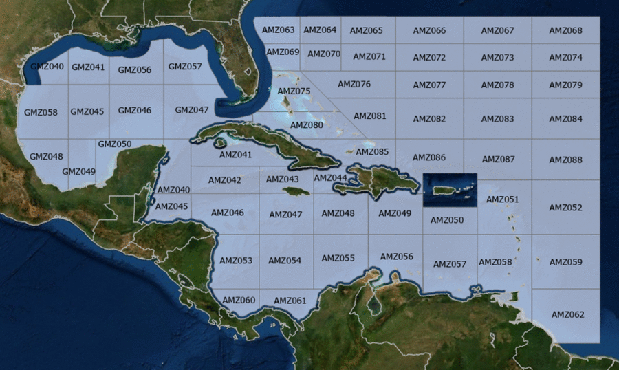
Hover to view popup zone forecast; click a zone to view related text forecast below.Show All Text Below
Southwest Tropical North Atlantic & Caribbean Sea (OFFNT3)
000
FZNT23 KNHC 131412
OFFNT3

Offshore Waters Forecast for the Caribbean Sea and Tropical
N Atlantic
NWS National Hurricane Center Miami, FL
1012 AM EDT Mon May 13 2024

Offshore Waters Forecast for Caribbean Sea, and the Tropical N
Atlantic from 07N to 19N W of 55W.

Seas given as significant wave height, which is the average
height of the highest 1/3 of the waves. Individual waves may be
more than twice the significant wave height.
Synopsis for the Caribbean Sea & Tropical North Atlantic
AMZ001-140100-
Synopsis for Caribbean Sea, and Tropical N Atlantic from 07N to
19N W of 55W
1012 AM EDT Mon May 13 2024

.SYNOPSIS...High pressure over the central Atlantic will support
strong to near gale E to SE winds near the Gulf of Honduras,
with fresh to strong winds expected in the south-central basin
through most of the week. Seas will build through the week as a
result of the increasing winds. Gentle to moderate winds are
expected elsewhere through most of the week. Meanwhile, haze due
to agricultural fires in Central America continues across some
areas of the northwestern Caribbean.
AMZ040 Zone Forecast
AMZ040-140100-
Caribbean N of 18N W of 85W including Yucatan Basin-
1012 AM EDT Mon May 13 2024

.TODAY...SE winds 20 kt. Seas 5 to 7 ft. Haze. Vsby 3 NM.
.TONIGHT...E to SE winds 20 to 25 kt S of 20N, and SE 15 to 20 kt
N of 20N. Seas 5 to 7 ft. Haze. Vsby 3 NM.
.TUE...SE winds 20 to 25 kt. Seas 6 to 9 ft in SE to S swell.
.TUE NIGHT...E to SE winds 20 to 25 kt S of 20N, and SE 15 to
20 kt N of 20N. Seas 6 to 8 ft.
.WED...SE winds 20 to 25 kt S of 20N, and SE to S 15 to 20 kt N
of 20N. Seas 6 to 9 ft in SE swell.
.WED NIGHT...E to SE winds 20 to 25 kt S of 20N, and SE 10 to
15 kt N of 20N. Seas 5 to 7 ft.
.THU...SE winds 15 to 20 kt. Seas 6 to 8 ft in SE swell.
.THU NIGHT...E to SE winds 20 to 25 kt S of 20N, and SE 15 to
20 kt N of 20N. Seas 6 to 8 ft.
.FRI...SE winds 20 to 25 kt. Seas 6 to 9 ft in SE swell.
.FRI NIGHT...SE winds 20 to 25 kt. Seas 6 to 9 ft in SE swell.
Forecaster Lewitsky
AMZ041 Zone Forecast
AMZ041-140100-
Caribbean N of 20N E of 85W-
1012 AM EDT Mon May 13 2024

.TODAY...SE winds 10 to 15 kt. Seas 3 to 5 ft. Haze.
.TONIGHT...SE winds 10 to 15 kt. Seas 3 to 5 ft. Haze.
.TUE...SE winds 15 to 20 kt W of 81W, and E to SE 10 to 15 kt E
of 81W. Seas 4 to 6 ft.
.TUE NIGHT...SE winds 15 to 20 kt W of 81W, and SE 10 kt E of
81W. Seas 4 to 6 ft.
.WED...SE to S winds 10 to 15 kt. Seas 4 to 6 ft.
.WED NIGHT...SE winds 10 to 15 kt W of 81W, and variable less
than 5 kt E of 81W. Seas 4 to 6 ft.
.THU...W of 81W, SE winds 10 to 15 kt. E of 81W, variable winds
less than 5 kt, becoming SE to S 10 kt in the afternoon. Seas
3 to 5 ft.
.THU NIGHT...W of 81W, SE winds 10 to 15 kt. E of 81W, variable
winds less than 5 kt, becoming E to SE 10 kt late. Seas
3 to 5 ft.
.FRI...W of 81W, SE winds 15 to 20 kt. Seas 4 to 6 ft. E of 81W,
SE winds 10 kt. Seas 3 ft or less.
.FRI NIGHT...W of 81W, SE winds 15 to 20 kt. Seas 4 to 6 ft. E of
81W, SE winds 10 kt. Seas 3 ft or less.
Forecaster Lewitsky
AMZ042 Zone Forecast
AMZ042-140100-
Caribbean from 18N to 20N between 80W and 85W including Cayman
Basin-
1012 AM EDT Mon May 13 2024

.TODAY...SE winds 15 to 20 kt W of 82W, and E to SE 10 to 15 kt E
of 82W. Seas 3 to 5 ft. Haze.
.TONIGHT...SE winds 15 to 20 kt W of 82W, and E to SE 10 to 15 kt
E of 82W. Seas 3 to 5 ft. Haze.
.TUE...SE winds 15 to 20 kt. Seas 4 to 6 ft in SE swell.
.TUE NIGHT...SE winds 15 to 20 kt W of 82W, and SE 10 to 15 kt E
of 82W. Seas 4 to 6 ft in SE swell.
.WED...SE winds 15 to 20 kt W of 82W, and SE 10 to 15 kt E of
82W. Seas 4 to 6 ft in SE swell.
.WED NIGHT...SE winds 15 to 20 kt W of 82W, and SE 10 to 15 kt E
of 82W. Seas 4 to 6 ft in SE swell.
.THU...W of 82W, SE winds 15 to 20 kt. Seas 5 to 7 ft. E of 82W,
SE winds 10 to 15 kt. Seas 3 to 5 ft.
.THU NIGHT...W of 82W, SE winds 15 to 20 kt. Seas 4 to 6 ft. E of
82W, SE winds 10 to 15 kt. Seas 2 to 4 ft.
.FRI...W of 82W, SE winds 15 to 20 kt. Seas 4 to 6 ft. E of 82W,
E to SE winds 10 to 15 kt. Seas 2 to 4 ft.
.FRI NIGHT...W of 82W, SE winds 15 to 20 kt. Seas 4 to 6 ft. E of
82W, SE winds 10 to 15 kt. Seas 2 to 4 ft.
Forecaster Lewitsky
AMZ043 Zone Forecast
AMZ043-140100-
Caribbean from 18N to 20N between 76W and 80W-
1012 AM EDT Mon May 13 2024

.TODAY...E winds 10 to 15 kt. Seas 3 ft or less.
.TONIGHT...E to SE winds 10 to 15 kt. Seas 2 to 4 ft.
.TUE...E to SE winds 10 to 15 kt W of 78W, and E to SE 15 to
20 kt E of 78W. Seas 3 to 5 ft.
.TUE NIGHT...E to SE winds 10 to 15 kt W of 78W, and E to SE
15 to 20 kt E of 78W. Seas 3 to 5 ft.
.WED...E to SE winds 10 to 15 kt. Seas 3 to 5 ft.
.WED NIGHT...E to SE winds 10 to 15 kt. Seas 3 to 5 ft.
.THU...SE winds 10 to 15 kt. Seas 3 to 5 ft.
.THU NIGHT...E to SE winds 10 kt. Seas 2 to 4 ft.
.FRI...E to SE winds 10 to 15 kt. Seas 2 to 4 ft.
.FRI NIGHT...E to SE winds 10 to 15 kt. Seas 2 to 4 ft.
Forecaster Lewitsky
AMZ044 Zone Forecast
AMZ044-140100-
Caribbean approaches to the Windward Passage-
1012 AM EDT Mon May 13 2024

.TODAY...Variable winds less than 5 kt in the Gulf of Gonave, and
E 10 kt elsewhere. Seas 2 to 4 ft.
.TONIGHT...In the Gulf of Gonave, N winds 10 kt in the evening,
becoming variable less than 5 kt. Elsewhere, NE to E winds 10 to
15 kt. Seas 3 to 5 ft.
.TUE...In the Gulf of Gonave, SE winds 10 kt in the morning,
becoming variable less than 5 kt. Elsewhere, E to SE winds 10 to
15 kt. Seas 4 to 6 ft.
.TUE NIGHT...In the Gulf of Gonave, NW to N winds 10 kt in the
evening, becoming variable less than 5 kt. Elsewhere, NE to E
winds 10 to 15 kt. Seas 4 to 6 ft.
.WED...In the Gulf of Gonave, variable winds less than 5 kt.
Elsewhere, E winds 10 kt, shifting to S in the afternoon. Seas
3 ft or less in the Gulf of Gonave, and 4 to 6 ft elsewhere.
.WED NIGHT...In the Gulf of Gonave, NW to N winds 10 kt in the
evening, becoming variable less than 5 kt. Elsewhere, S winds
10 kt, shifting to E late. Seas 3 ft or less in the
Gulf of Gonave, and 3 to 5 ft elsewhere.
.THU...In the Gulf of Gonave, variable winds less than 5 kt.
Seas 3 ft or less. Elsewhere, S winds 10 kt. Seas 3 to 5 ft.
.THU NIGHT...In the Gulf of Gonave, variable winds less than
5 kt. Seas 3 ft or less. Elsewhere, E winds 10 kt. Seas 2 to
4 ft.
.FRI...In the Gulf of Gonave, variable winds less than 5 kt. Seas
3 ft or less. Elsewhere, E winds 10 to 15 kt. Seas 2 to 4 ft.
.FRI NIGHT...In the Gulf of Gonave, variable winds less than
5 kt. Seas 3 ft or less. Elsewhere, E winds 10 to 15 kt. Seas
2 to 4 ft.
Forecaster Lewitsky
AMZ045 Zone Forecast
AMZ045-140100-
S of 18N W of 85W including Gulf of Honduras-
1012 AM EDT Mon May 13 2024

.TODAY...E winds 15 to 20 kt S of 17N W of 86W, and E to SE 20 to
25 kt elsewhere. Seas 5 to 7 ft in E swell. Haze. Vsby 3 NM.
.TONIGHT...E to SE winds 25 to 30 kt. Seas 6 to 9 ft. Haze.
Vsby 3 NM.
.TUE...E to SE winds 20 to 25 kt. Seas 6 to 9 ft in E swell.
.TUE NIGHT...E winds 20 to 30 kt S of 17N W of 86W, and E to SE
20 to 25 kt elsewhere. Seas 6 to 8 ft.
.WED...S of 17N W of 86W, SE to S winds 20 to 25 kt, becoming E
10 to 15 kt in the afternoon. Elsewhere, E to SE winds 20 to
25 kt. Seas 6 to 9 ft in E swell.
.WED NIGHT...E winds 20 to 30 kt S of 17N W of 86W, and E to SE
20 to 25 kt elsewhere. Seas 6 to 8 ft.
.THU...E to SE winds 15 to 20 kt S of 17N W of 86W, and E to SE
20 to 25 kt elsewhere. Seas 6 to 9 ft in E swell.
.THU NIGHT...E to SE winds 20 to 25 kt. Seas 6 to 8 ft.
.FRI...E to SE winds 20 to 25 kt. Seas 6 to 9 ft in E swell.
.FRI NIGHT...Winds E to SE winds 20 to 30 kt. Seas 7 to 10 ft in
E swell.
Forecaster Lewitsky
AMZ046 Zone Forecast
AMZ046-140100-
Caribbean from 15N to 18N between 80W and 85W-
1012 AM EDT Mon May 13 2024

.TODAY...E to SE winds 15 kt. Seas 3 to 5 ft. Haze.
.TONIGHT...E to SE winds 15 to 20 kt. Seas 4 to 6 ft. Haze.
.TUE...E to SE winds 15 to 20 kt. Seas 4 to 6 ft.
.TUE NIGHT...E to SE winds 15 to 20 kt. Seas 4 to 6 ft.
.WED...E to SE winds 15 to 20 kt. Seas 4 to 6 ft.
.WED NIGHT...E to SE winds 15 to 20 kt. Seas 5 to 7 ft W of 82W,
and 4 to 6 ft E of 82W.
.THU...E to SE winds 15 to 20 kt. Seas 5 to 7 ft W of 82W, and
4 to 6 ft E of 82W.
.THU NIGHT...E to SE winds 20 to 25 kt W of 82W, and E to SE
15 kt E of 82W. Seas 4 to 6 ft.
.FRI...E to SE winds 15 to 20 kt. Seas 4 to 6 ft W of 82W, and
3 to 5 ft E of 82W.
.FRI NIGHT...E to SE winds 15 to 20 kt. Seas 4 to 6 ft W of 82W,
and 3 to 5 ft E of 82W.
Forecaster Lewitsky
AMZ047 Zone Forecast
AMZ047-140100-
Caribbean from 15N to 18N between 76W and 80W-
1012 AM EDT Mon May 13 2024

.TODAY...E winds 15 to 20 kt. Seas 3 to 5 ft.
.TONIGHT...E winds 15 to 20 kt. Seas 5 to 7 ft.
.TUE...E winds 15 to 20 kt. Seas 6 to 8 ft.
.TUE NIGHT...E winds 15 to 20 kt. Seas 6 to 8 ft in E to SE
swell.
.WED...E winds 15 to 20 kt. Seas 6 to 8 ft.
.WED NIGHT...E winds 15 kt. Seas 5 to 7 ft in E to SE swell.
.THU...E to SE winds 15 kt. Seas 4 to 6 ft.
.THU NIGHT...E winds 15 to 20 kt S of 17N, and E to SE 10 to
15 kt N of 17N. Seas 3 to 5 ft.
.FRI...E winds 15 kt. Seas 3 to 5 ft.
.FRI NIGHT...E winds 15 to 20 kt. Seas 4 to 6 ft.
Forecaster Lewitsky
AMZ048 Zone Forecast
AMZ048-140100-
Caribbean from 15N to 18N between 72W and 76W-
1012 AM EDT Mon May 13 2024

.TODAY...E winds 15 to 20 kt. Seas 4 to 6 ft.
.TONIGHT...E winds 15 to 20 kt. Seas 5 to 7 ft.
.TUE...E winds 15 to 20 kt. Seas 6 to 8 ft.
.TUE NIGHT...E winds 15 to 20 kt. Seas 6 to 8 ft in SE swell.
.WED...E winds 15 to 20 kt. Seas 6 to 8 ft.
.WED NIGHT...E winds 15 to 20 kt S of 17N, and E to SE 10 to
15 kt N of 17N. Seas 5 to 7 ft.
.THU...E winds 10 to 15 kt. Seas 4 to 6 ft.
.THU NIGHT...E winds 10 to 15 kt. Seas 3 to 5 ft.
.FRI...E winds 15 kt. Seas 3 to 5 ft.
.FRI NIGHT...E winds 15 to 20 kt S of 17N, and E 10 to 15 kt
N of 17N. Seas 4 to 6 ft.
Forecaster Lewitsky
AMZ049 Zone Forecast
AMZ049-140100-
Caribbean N of 15N between 68W and 72W-
1012 AM EDT Mon May 13 2024

.TODAY...E winds 15 to 20 kt W of 70W, and E to SE 10 to 15 kt E
of 70W. Seas 4 to 6 ft.
.TONIGHT...E winds 15 to 20 kt. Seas 5 to 7 ft in SE swell.
.TUE...E winds 15 to 20 kt. Seas 5 to 7 ft in SE swell.
.TUE NIGHT...E winds 15 to 20 kt W of 70W, and E 10 to 15 kt E of
70W. Seas 5 to 7 ft in SE swell.
.WED...E winds 15 to 20 kt W of 70W, and E 10 to 15 kt E of 70W.
Seas 5 to 7 ft in SE swell.
.WED NIGHT...E winds 10 to 15 kt. Seas 4 to 6 ft.
.THU...E winds 10 to 15 kt. Seas 3 to 5 ft.
.THU NIGHT...E winds 10 to 15 kt. Seas 3 to 5 ft.
.FRI...E winds 10 to 15 kt. Seas 3 to 5 ft.
.FRI NIGHT...E winds 15 to 20 kt W of 70W, and E 10 to 15 kt E of
70W. Seas 3 to 5 ft.
Forecaster Lewitsky
AMZ050 Zone Forecast
AMZ050-140100-
Caribbean N of 15N between 64W and 68W-
1012 AM EDT Mon May 13 2024

.TODAY...E winds 10 to 15 kt. Seas 3 to 5 ft.
.TONIGHT...E winds 10 to 15 kt. Seas 3 to 5 ft.
.TUE...E winds 10 to 15 kt. Seas 3 to 5 ft.
.TUE NIGHT...E winds 15 kt. Seas 3 to 5 ft.
.WED...E winds 10 to 15 kt. Seas 3 to 5 ft.
.WED NIGHT...E winds 10 to 15 kt. Seas 3 to 5 ft.
.THU...E winds 10 to 15 kt. Seas 2 to 4 ft.
.THU NIGHT...E winds 10 to 15 kt. Seas 2 to 4 ft.
.FRI...E winds 10 to 15 kt. Seas 2 to 4 ft.
.FRI NIGHT...E winds 10 to 15 kt. Seas 3 to 5 ft.
Forecaster Lewitsky
AMZ051 Zone Forecast
AMZ051-140100-
Offshore Waters Leeward Islands-
1012 AM EDT Mon May 13 2024

.TODAY...E winds 10 kt. Seas 2 to 4 ft.
.TONIGHT...E winds 10 to 15 kt. Seas 2 to 4 ft.
.TUE...NE to E winds 10 to 15 kt. Seas 2 to 4 ft.
.TUE NIGHT...NE to E winds 10 to 15 kt. Seas 3 to 5 ft.
.WED...E winds 10 kt. Seas 3 to 5 ft.
.WED NIGHT...E winds 10 to 15 kt. Seas 3 to 5 ft.
.THU...E winds 10 kt. Seas 3 to 5 ft.
.THU NIGHT...E winds 10 to 15 kt. Seas 3 to 5 ft.
.FRI...E winds 10 to 15 kt. Seas 3 to 5 ft.
.FRI NIGHT...E winds 10 to 15 kt. Seas 4 to 6 ft.
Forecaster Lewitsky
AMZ052 Zone Forecast
AMZ052-140100-
Tropical N Atlantic from 15N to 19N between 55W and 60W-
1012 AM EDT Mon May 13 2024

.TODAY...E winds 10 kt. Seas 3 to 5 ft.
.TONIGHT...E winds 10 to 15 kt. Seas 3 to 5 ft.
.TUE...E winds 10 kt. Seas 3 to 5 ft.
.TUE NIGHT...NE to E winds 10 to 15 kt. Seas 3 to 5 ft.
.WED...E winds 10 kt. Seas 3 to 5 ft.
.WED NIGHT...E winds 10 kt. Seas 3 to 5 ft.
.THU...E to SE winds 10 to 15 kt. Seas 3 to 5 ft.
.THU NIGHT...E winds 10 to 15 kt. Seas 4 to 6 ft.
.FRI...E winds 10 to 15 kt S of 17N, and E 10 kt N of 17N.
Seas 4 to 6 ft.
.FRI NIGHT...E winds 10 to 15 kt. Seas 4 to 6 ft.
Forecaster Lewitsky
AMZ053 Zone Forecast
AMZ053-140100-
W Central Caribbean from 11N to 15N W of 80W-
1012 AM EDT Mon May 13 2024

.TODAY...NE to E winds 15 kt. Seas 3 to 5 ft.
.TONIGHT...NE to E winds 10 to 15 kt. Seas 3 to 5 ft.
.TUE...NE to E winds 10 to 15 kt. Seas 4 to 6 ft.
.TUE NIGHT...E winds 15 to 20 kt. Seas 5 to 7 ft.
Scattered showers and isolated tstms.
.WED...E winds 15 to 20 kt. Seas 5 to 7 ft.
.WED NIGHT...E winds 10 to 15 kt. Seas 5 to 7 ft in E swell.
.THU...E winds 15 to 20 kt. Seas 5 to 7 ft.
.THU NIGHT...E winds 10 to 15 kt. Seas 4 to 6 ft.
.FRI...E winds 10 to 15 kt. Seas 3 to 5 ft.
.FRI NIGHT...E winds 10 to 15 kt. Seas 3 to 5 ft.
Forecaster Lewitsky
AMZ054 Zone Forecast
AMZ054-140100-
Caribbean from 11N to 15N between 76W and 80W-
1012 AM EDT Mon May 13 2024

.TODAY...NE to E winds 15 to 20 kt. Seas 5 to 7 ft.
.TONIGHT...NE to E winds 15 to 20 kt. Seas 6 to 8 ft.
.TUE...NE to E winds 15 to 20 kt W of 78W, and NE to E 20 to
25 kt E of 78W. Seas 6 to 9 ft in E swell.
.TUE NIGHT...E winds 15 to 20 kt. Seas 6 to 9 ft in E swell.
.WED...E winds 15 to 20 kt. Seas 6 to 9 ft in E swell.
.WED NIGHT...Winds E winds 15 to 20 kt. Seas 6 to 8 ft.
.THU...E winds 15 to 20 kt. Seas 5 to 7 ft.
.THU NIGHT...E winds 10 to 15 kt W of 78W, and NE to E 15 to
20 kt E of 78W. Seas 4 to 6 ft.
.FRI...E winds 10 to 15 kt W of 78W, and E 15 to 20 kt E of 78W.
Seas 4 to 6 ft.
.FRI NIGHT...NE to E winds 15 to 20 kt. Seas 5 to 7 ft.
Forecaster Lewitsky
AMZ055 Zone Forecast
AMZ055-140100-
Caribbean from 11N to 15N between 72W and 76W including Colombia
Basin-
1012 AM EDT Mon May 13 2024

.TODAY...NE to E winds 20 kt. Seas 6 to 8 ft in E swell.
.TONIGHT...NE to E winds 20 to 25 kt. Seas 6 to 9 ft in E swell.
.TUE...E winds 20 to 25 kt. Seas 6 to 9 ft in E swell.
.TUE NIGHT...E winds 20 to 25 kt. Seas 6 to 9 ft in E swell.
.WED...E winds 15 to 20 kt. Seas 6 to 9 ft in E swell.
.WED NIGHT...NE to E winds 20 to 25 kt S of 13N, and E 15 to
20 kt N of 13N. Seas 6 to 8 ft.
.THU...E winds 15 to 20 kt. Seas 5 to 7 ft.
.THU NIGHT...NE to E winds 15 to 20 kt. Seas 4 to 6 ft.
.FRI...E winds 15 to 20 kt. Seas 5 to 7 ft.
.FRI NIGHT...NE to E winds 20 to 25 kt. Seas 6 to 8 ft.
Forecaster Lewitsky
AMZ056 Zone Forecast
AMZ056-140100-
Caribbean S of 15N between 68W and 72W including Gulf of
Venezuela-
1012 AM EDT Mon May 13 2024

.TODAY...E winds 15 to 20 kt. Seas 5 to 7 ft.
.TONIGHT...E winds 20 to 25 kt. Seas 6 to 8 ft.
.TUE...E winds 20 to 25 kt. Seas 6 to 8 ft.
.TUE NIGHT...E winds 20 to 25 kt. Seas 6 to 8 ft.
.WED...E winds 15 to 20 kt. Seas 6 to 8 ft.
.WED NIGHT...E winds 20 to 25 kt S of 13N, and E 15 to 20 kt
N of 13N. Seas 4 to 6 ft.
.THU...E winds 15 to 20 kt. Seas 4 to 6 ft.
.THU NIGHT...E winds 15 to 20 kt. Seas 4 to 6 ft.
.FRI...E winds 15 to 20 kt. Seas 4 to 6 ft.
.FRI NIGHT...E winds 20 kt. Seas 4 to 6 ft.
Forecaster Lewitsky
AMZ057 Zone Forecast
AMZ057-140100-
Caribbean S of 15N between 64W and 68W including Venezuela Basin-
1012 AM EDT Mon May 13 2024

.TODAY...E winds 15 to 20 kt. Seas 4 to 6 ft.
.TONIGHT...E winds 15 to 20 kt. Seas 4 to 6 ft.
.TUE...E winds 15 to 20 kt. Seas 5 to 7 ft.
.TUE NIGHT...NE to E winds 15 to 20 kt. Seas 4 to 6 ft.
.WED...E winds 15 kt. Seas 4 to 6 ft.
.WED NIGHT...E winds 15 to 20 kt. Seas 3 to 5 ft.
.THU...E winds 15 kt. Seas 3 to 5 ft.
.THU NIGHT...E winds 15 to 20 kt. Seas 3 to 5 ft.
.FRI...E winds 15 to 20 kt. Seas 3 to 5 ft.
.FRI NIGHT...E winds 15 to 20 kt. Seas 3 to 5 ft.
Forecaster Lewitsky
AMZ058 Zone Forecast
AMZ058-140100-
Offshore Waters Windward Islands including Trinidad and Tobago-
1012 AM EDT Mon May 13 2024

.TODAY...E winds 10 to 15 kt. Seas 3 to 5 ft.
.TONIGHT...E winds 10 to 15 kt. Seas 3 to 5 ft.
.TUE...E winds 10 to 15 kt. Seas 3 to 5 ft.
.TUE NIGHT...E winds 10 to 15 kt. Seas 3 to 5 ft.
.WED...E winds 10 to 15 kt. Seas 3 to 5 ft.
.WED NIGHT...E winds 10 to 15 kt. Seas 3 to 5 ft.
.THU...E winds 10 to 15 kt. Seas 3 to 5 ft.
.THU NIGHT...E winds 10 to 15 kt. Seas 3 to 5 ft.
.FRI...E winds 10 to 15 kt. Seas 3 to 5 ft.
.FRI NIGHT...E winds 15 kt. Seas 4 to 6 ft.
Forecaster Lewitsky
AMZ059 Zone Forecast
AMZ059-140100-
Tropical N Atlantic from 11N and 15N between 55W and 60W-
1012 AM EDT Mon May 13 2024

.TODAY...E winds 10 to 15 kt. Seas 3 to 5 ft.
.TONIGHT...E winds 10 to 15 kt. Seas 3 to 5 ft.
.TUE...E winds 10 to 15 kt. Seas 4 to 6 ft.
.TUE NIGHT...NE to E winds 15 kt. Seas 4 to 6 ft.
.WED...E winds 10 to 15 kt. Seas 4 to 6 ft.
.WED NIGHT...E winds 10 to 15 kt. Seas 4 to 6 ft.
.THU...E winds 15 kt. Seas 4 to 6 ft.
.THU NIGHT...E winds 15 kt. Seas 4 to 6 ft.
.FRI...E winds 15 kt. Seas 4 to 6 ft.
.FRI NIGHT...E winds 15 to 20 kt. Seas 5 to 7 ft.
Forecaster Lewitsky
AMZ060 Zone Forecast
AMZ060-140100-
SW Caribbean S of 11N W of 80W-
1012 AM EDT Mon May 13 2024

.TODAY...NE winds 10 to 15 kt. Seas 3 to 5 ft. Scattered tstms.
.TONIGHT...S of 10N, N to NE winds 10 kt in the evening, becoming
variable less than 5 kt. N of 10N, NE to E winds 10 to 15 kt.
Seas 3 to 5 ft. Scattered showers and isolated tstms.
.TUE...Variable winds less than 5 kt S of 10N, and NE to E 10 to
15 kt N of 10N. Seas 3 to 5 ft. Scattered showers and isolated
tstms.
.TUE NIGHT...S of 10N, variable winds less than 5 kt, becoming W
to NW 10 kt late. N of 10N, NE winds 10 kt in the
evening, becoming variable less than 5 kt. Seas 4 to 6 ft.
.WED...S of 10N, variable winds less than 5 kt, becoming W to NW
10 kt in the afternoon. N of 10N, variable winds less than 5 kt.
Seas 3 to 5 ft.
.WED NIGHT...Variable winds less than 5 kt. Seas 3 to 5 ft in NE
to E swell.
.THU...Variable winds less than 5 kt. Seas 3 to 5 ft in NE to E
swell.
.THU NIGHT...S of 10N, variable less than 5 kt. Variable winds
less than 5 kt in the evening. N of 10N, E winds 10 kt late. Seas
2 to 4 ft in NE to E swell.
.FRI...S of 10N, variable winds less than 5 kt in the morning.
Variable winds less than 5 kt in the afternoon. N of 10N, E to SE
winds 10 kt in the morning. Seas 2 to 4 ft in NE to E swell.
.FRI NIGHT...S of 10N, variable less than 5 kt. Variable winds
less than 5 kt in the evening. N of 10N, NE to E winds 10 kt
late. Seas 2 to 4 ft in NE to E swell.
Forecaster Lewitsky
AMZ061 Zone Forecast
AMZ061-140100-
SW Caribbean S of 11N E of 80W including the approaches to the
Panama Canal-
1012 AM EDT Mon May 13 2024

.TODAY...NE winds 10 to 15 kt. Seas 5 to 7 ft in NE swell.
Scattered showers and isolated tstms.
.TONIGHT...N to NE winds 10 to 15 kt S of 10N, and NE 15 to 20 kt
N of 10N. Seas 4 to 6 ft. Scattered showers and isolated tstms.
.TUE...E winds 10 to 15 kt. Seas 5 to 7 ft in NE swell.
.TUE NIGHT...Variable winds less than 5 kt S of 10N, and E 10 kt
N of 10N. Seas 5 to 7 ft in NE swell. Scattered showers and
isolated tstms.
.WED...S to SW winds 10 kt. Seas 4 to 6 ft in NE swell.
.WED NIGHT...S of 10N, variable winds less than 5 kt, becoming W
10 kt late. N of 10N, variable winds less than 5 kt.
Seas 3 to 5 ft.
.THU...S of 10N, variable winds less than 5 kt in the morning.
Variable winds less than 5 kt in the afternoon. N of 10N, NE to E
winds 10 kt in the morning. Seas 3 to 5 ft.
.THU NIGHT...Variable winds less than 5 kt S of 10N, and NE 10 kt
N of 10N. Seas 3 to 5 ft.
.FRI...Variable winds less than 5 kt S of 10N, and NE to E 10 kt
N of 10N. Seas 3 to 5 ft.
.FRI NIGHT...Variable winds less than 5 kt S of 10N, and NE 10 to
15 kt N of 10N. Seas 3 to 5 ft.
Forecaster Lewitsky
AMZ062 Zone Forecast
AMZ062-140100-
Tropical N Atlantic from 7N and 11N between 55W and 60W-
1012 AM EDT Mon May 13 2024

.TODAY...E winds 10 to 15 kt. Seas 3 to 5 ft.
.TONIGHT...E winds 15 kt. Seas 4 to 6 ft.
.TUE...E winds 10 to 15 kt. Seas 4 to 6 ft.
.TUE NIGHT...NE to E winds 15 kt. Seas 4 to 6 ft.
Scattered showers and isolated tstms.
.WED...E winds 10 to 15 kt. Seas 4 to 6 ft.
.WED NIGHT...E winds 10 to 15 kt. Seas 4 to 6 ft.
.THU...E winds 10 to 15 kt. Seas 4 to 6 ft.
.THU NIGHT...E winds 15 kt. Seas 4 to 6 ft.
.FRI...E winds 15 kt. Seas 4 to 6 ft.
.FRI NIGHT...E winds 15 kt. Seas 4 to 6 ft.
000
FZNT25 KNHC 131412
OFFNT5

Offshore Waters Forecast for SW N Atlantic including the Bahamas
NWS National Hurricane Center Miami, FL
1012 AM EDT Mon May 13 2024

Offshore Waters Forecast for the SW N Atlantic from 19N to 31N W
of 55W including Bahamas.

Seas given as significant wave height, which is the average
height of the highest 1/3 of the waves. Individual waves may be
more than twice the significant wave height.
Synopsis for the Southwest Atlantic
AMZ101-140045-
Synopsis for the SW N Atlantic including the Bahamas
1012 AM EDT Mon May 13 2024

.SYNOPSIS...A cold front extends from near 31N61W to 24N65W where
it becomes stationary to the Central Bahamas. Scattered
thunderstorms are ahead of it N of 27N. The front will weaken as
it reaches from near 26N55W to 22N65W by early Tue. High pressure
will build in its wake. Fresh to strong southerly winds and
building seas are forecast offshore N Florida by Tue ahead of
another possible cold front. That front may reach from near
31N76W to 27N80W by early Thu, weakening and stalling from 31N69W
to near Fort Pierce, Florida by early Fri. Conditions around the
front will improve by late Fri.
AMZ063 Zone Forecast
AMZ063-140045-
Atlantic from 29N to 31N W of 77W-
1012 AM EDT Mon May 13 2024

.TODAY...E to SE winds 10 to 15 kt. Seas 3 ft or less.
.TONIGHT...SE winds 15 to 20 kt. Seas 3 to 5 ft.
Scattered showers and isolated tstms.
.TUE...S winds 15 to 20 kt. Seas 4 to 6 ft.
Scattered showers and isolated tstms.
.TUE NIGHT...S to SW winds 20 to 25 kt. Seas 4 to 6 ft.
Scattered tstms.
.WED...SW to W winds 15 to 20 kt. Seas 4 to 6 ft.
.WED NIGHT...SW to W winds 15 to 20 kt. Seas 4 to 6 ft.
.THU...W to NW winds 10 to 15 kt. Seas 3 to 5 ft.
.THU NIGHT...SW to W winds 10 kt. Seas 2 to 4 ft.
.FRI...Variable winds less than 5 kt. Seas 2 to 4 ft.
.FRI NIGHT...S winds 10 kt. Seas 3 ft or less.
Forecaster Lewitsky
AMZ064 Zone Forecast
AMZ064-140045-
Atlantic from 29N to 31N between 74W and 77W-
1012 AM EDT Mon May 13 2024

.TODAY...NE winds 10 kt, shifting to E to SE in the afternoon.
Seas 2 to 4 ft.
.TONIGHT...SE winds 10 to 15 kt. Seas 2 to 4 ft.
.TUE...SE to S winds 15 to 20 kt. Seas 3 to 5 ft.
Scattered showers and isolated tstms.
.TUE NIGHT...S to SW winds 20 to 25 kt. Seas 4 to 6 ft.
Scattered showers and isolated tstms.
.WED...SW winds 15 to 20 kt. Seas 5 to 7 ft.
.WED NIGHT...SW winds 15 to 20 kt. Seas 5 to 7 ft.
.THU...SW to W winds 10 to 15 kt. Seas 4 to 6 ft.
.THU NIGHT...W to NW winds 10 to 15 kt. Seas 3 to 5 ft.
.FRI...Variable winds less than 5 kt. Seas 2 to 4 ft.
.FRI NIGHT...S winds 10 kt. Seas 2 to 4 ft.
Forecaster Lewitsky
AMZ065 Zone Forecast
AMZ065-140045-
Atlantic from 29N to 31N between 70W and 74W-
1012 AM EDT Mon May 13 2024

.TODAY...N to NE winds 10 kt. Seas 3 to 5 ft.
.TONIGHT...NE to E winds 10 to 15 kt. Seas 3 to 5 ft.
.TUE...SE winds 10 to 15 kt. Seas 3 to 5 ft.
.TUE NIGHT...SE to S winds 15 to 20 kt. Seas 4 to 6 ft.
.WED...S to SW winds 15 to 20 kt. Seas 4 to 6 ft.
.WED NIGHT...S to SW winds 20 to 25 kt. Seas 5 to 7 ft.
.THU...SW winds 20 to 25 kt. Seas 6 to 8 ft.
.THU NIGHT...W winds 10 to 15 kt. Seas 5 to 7 ft.
.FRI...W to NW winds 10 kt. Seas 4 to 6 ft.
.FRI NIGHT...Variable winds less than 5 kt. Seas 3 to 5 ft.
Forecaster Lewitsky
AMZ066 Zone Forecast
AMZ066-140045-
Atlantic from 29N to 31N between 65W and 70W-
1012 AM EDT Mon May 13 2024

.TODAY...NW to N winds 10 to 15 kt. Seas 4 to 6 ft.
.TONIGHT...N to NE winds 10 to 15 kt. Seas 3 to 5 ft.
.TUE...NE winds 10 kt in the morning, becoming variable
less than 5 kt. Seas 3 to 5 ft.
.TUE NIGHT...E to SE winds 10 kt. Seas 3 to 5 ft.
.WED...SE to S winds 10 to 15 kt. Seas 3 to 5 ft.
.WED NIGHT...S winds 15 to 20 kt. Seas 3 to 5 ft.
.THU...S to SW winds 15 to 20 kt. Seas 5 to 7 ft.
.THU NIGHT...SW winds 15 to 20 kt. Seas 5 to 7 ft.
.FRI...SW to W winds 15 to 20 kt. Seas 4 to 6 ft.
.FRI NIGHT...W winds 10 kt. Seas 4 to 6 ft.
Forecaster Lewitsky
AMZ067 Zone Forecast
AMZ067-140045-
Atlantic from 29N to 31N between 60W and 65W-
1012 AM EDT Mon May 13 2024

.TODAY...NW winds 10 to 15 kt. Seas 4 to 6 ft.
.TONIGHT...NW to N winds 10 to 15 kt. Seas 4 to 6 ft.
.TUE...NW to N winds 10 to 15 kt. Seas 4 to 6 ft.
.TUE NIGHT...N winds 10 to 15 kt in the evening, becoming
variable less than 5 kt. Seas 4 to 6 ft.
.WED...Variable winds less than 5 kt. Seas 3 to 5 ft.
.WED NIGHT...S winds 10 kt. Seas 3 to 5 ft.
.THU...S to SW winds 10 to 15 kt. Seas 3 to 5 ft.
.THU NIGHT...S winds 15 to 20 kt. Seas 4 to 6 ft.
.FRI...S to SW winds 15 to 20 kt. Seas 4 to 6 ft.
.FRI NIGHT...SW winds 10 to 15 kt. Seas 4 to 6 ft.
Forecaster Lewitsky
AMZ068 Zone Forecast
AMZ068-140045-
Atlantic from 29N to 31N between 55W and 60W-
1012 AM EDT Mon May 13 2024

.TODAY...SW winds 10 to 15 kt. Seas 4 to 6 ft.
Scattered showers and isolated tstms.
.TONIGHT...W to NW winds 10 to 15 kt. Seas 4 to 6 ft.
Scattered showers and isolated tstms.
.TUE...NW winds 10 to 15 kt. Seas 4 to 6 ft.
.TUE NIGHT...NW to N winds 10 to 15 kt. Seas 4 to 6 ft.
.WED...NW winds 10 kt. Seas 4 to 6 ft.
.WED NIGHT...NW to N winds 10 kt. Seas 4 to 6 ft.
.THU...S to SW winds 10 kt. Seas 3 to 5 ft.
.THU NIGHT...SE to S winds 10 kt. Seas 3 to 5 ft.
.FRI...S winds 10 to 15 kt. Seas 3 to 5 ft.
.FRI NIGHT...S winds 10 kt. Seas 3 to 5 ft.
Forecaster Lewitsky
AMZ069 Zone Forecast
AMZ069-140045-
Atlantic from 27N to 29N W of 77W-
1012 AM EDT Mon May 13 2024

.TODAY...E winds 10 to 15 kt. Seas 2 to 4 ft.
.TONIGHT...SE winds 15 to 20 kt. Seas 2 to 4 ft.
.TUE...S winds 15 to 20 kt. Seas 3 to 5 ft.
Scattered showers and isolated tstms.
.TUE NIGHT...S winds 15 to 20 kt. Seas 3 to 5 ft.
Isolated tstms.
.WED...SW winds 15 to 20 kt. Seas 3 to 5 ft.
.WED NIGHT...SW winds 15 to 20 kt. Seas 2 to 4 ft.
.THU...W winds 10 to 15 kt. Seas 2 to 4 ft.
.THU NIGHT...Variable winds less than 5 kt. Seas 2 to 4 ft.
.FRI...Variable winds less than 5 kt. Seas 3 ft or less.
.FRI NIGHT...S winds 10 kt. Seas 3 ft or less.
Forecaster Lewitsky
AMZ070 Zone Forecast
AMZ070-140045-
Atlantic from 27N to 29N between 74W and 77W-
1012 AM EDT Mon May 13 2024

.TODAY...E winds 10 to 15 kt. Seas 2 to 4 ft.
.TONIGHT...SE winds 10 to 15 kt. Seas 3 to 5 ft.
.TUE...SE to S winds 15 to 20 kt. Seas 3 to 5 ft.
.TUE NIGHT...S winds 15 to 20 kt. Seas 4 to 6 ft.
.WED...S to SW winds 15 to 20 kt. Seas 3 to 5 ft.
.WED NIGHT...S to SW winds 15 to 20 kt. Seas 3 to 5 ft.
.THU...SW to W winds 15 to 20 kt. Seas 4 to 6 ft.
.THU NIGHT...SW to W winds 10 to 15 kt. Seas 3 to 5 ft.
.FRI...Variable winds less than 5 kt. Seas 2 to 4 ft.
.FRI NIGHT...S winds 10 kt. Seas 2 to 4 ft.
Forecaster Lewitsky
AMZ071 Zone Forecast
AMZ071-140045-
Atlantic from 27N to 29N between 70W and 74W-
1012 AM EDT Mon May 13 2024

.TODAY...NE winds 10 kt. Seas 2 to 4 ft.
.TONIGHT...E winds 10 to 15 kt. Seas 2 to 4 ft.
.TUE...SE winds 10 to 15 kt. Seas 2 to 4 ft.
.TUE NIGHT...SE to S winds 15 to 20 kt. Seas 3 to 5 ft.
.WED...S winds 15 kt. Seas 3 to 5 ft.
.WED NIGHT...S to SW winds 15 to 20 kt. Seas 3 to 5 ft.
.THU...S to SW winds 15 to 20 kt. Seas 4 to 6 ft.
.THU NIGHT...SW to W winds 10 to 15 kt. Seas 4 to 6 ft.
.FRI...W winds 10 kt. Seas 3 to 5 ft.
.FRI NIGHT...Variable winds less than 5 kt. Seas 3 to 5 ft.
Forecaster Lewitsky
AMZ072 Zone Forecast
AMZ072-140045-
Atlantic from 27N to 29N between 65W and 70W-
1012 AM EDT Mon May 13 2024

.TODAY...N winds 10 to 15 kt. Seas 3 to 5 ft.
.TONIGHT...N to NE winds 10 kt. Seas 3 to 5 ft.
.TUE...NE to E winds 10 kt in the morning, becoming
variable less than 5 kt. Seas 3 to 5 ft.
.TUE NIGHT...E winds 10 kt. Seas 2 to 4 ft.
.WED...SE to S winds 10 to 15 kt. Seas 2 to 4 ft.
.WED NIGHT...S winds 10 to 15 kt. Seas 2 to 4 ft.
.THU...S to SW winds 15 to 20 kt. Seas 3 to 5 ft.
.THU NIGHT...SW winds 10 to 15 kt. Seas 4 to 6 ft.
.FRI...SW winds 15 to 20 kt. Seas 4 to 6 ft.
.FRI NIGHT...W winds 10 kt. Seas 3 to 5 ft.
Forecaster Lewitsky
AMZ073 Zone Forecast
AMZ073-140045-
Atlantic from 27N to 29N between 60W and 65W-
1012 AM EDT Mon May 13 2024

.TODAY...NW winds 10 to 15 kt. Seas 4 to 6 ft.
.TONIGHT...NW to N winds 10 to 15 kt. Seas 4 to 6 ft.
.TUE...N winds 10 kt. Seas 3 to 5 ft.
.TUE NIGHT...N to NE winds 10 kt in the evening, becoming
variable less than 5 kt. Seas 3 to 5 ft.
.WED...Variable winds less than 5 kt. Seas 3 to 5 ft.
.WED NIGHT...Variable winds less than 5 kt. Seas 3 to 5 ft.
.THU...S winds 10 to 15 kt. Seas 3 to 5 ft.
.THU NIGHT...S winds 10 to 15 kt. Seas 3 to 5 ft.
.FRI...S to SW winds 10 to 15 kt. Seas 3 to 5 ft.
.FRI NIGHT...S to SW winds 10 kt. Seas 3 to 5 ft.
Forecaster Lewitsky
AMZ074 Zone Forecast
AMZ074-140045-
Atlantic from 27N to 29N between 55W and 60W-
1012 AM EDT Mon May 13 2024

.TODAY...SW winds 10 to 15 kt. Seas 4 to 6 ft.
Scattered showers and isolated tstms.
.TONIGHT...W to NW winds 10 to 15 kt. Seas 4 to 6 ft.
.TUE...NW to N winds 10 to 15 kt. Seas 4 to 6 ft.
.TUE NIGHT...N winds 10 kt. Seas 3 to 5 ft.
.WED...Variable winds less than 5 kt. Seas 3 to 5 ft.
.WED NIGHT...Variable winds less than 5 kt. Seas 3 to 5 ft.
.THU...Variable winds less than 5 kt. Seas 3 to 5 ft.
.THU NIGHT...E to SE winds 10 kt. Seas 3 to 5 ft.
.FRI...SE to S winds 10 kt. Seas 2 to 4 ft.
.FRI NIGHT...SE to S winds 10 kt. Seas 2 to 4 ft.
Forecaster Lewitsky
AMZ075 Zone Forecast
AMZ075-140045-
Northern Bahamas from 24N to 27N-
1012 AM EDT Mon May 13 2024

.TODAY...E winds 10 to 15 kt. Seas 3 ft or less.
.TONIGHT...E to SE winds 15 to 20 kt. Seas 2 to 4 ft Atlc
Exposures, and 3 ft or less elsewhere.
.TUE...SE winds 10 to 15 kt. Seas 3 to 5 ft Atlc Exposures,
and 3 ft or less elsewhere.
.TUE NIGHT...SE winds 10 to 15 kt. Seas 2 to 4 ft Atlc
Exposures, and 3 ft or less elsewhere.
.WED...S winds 10 to 15 kt. Seas 3 ft or less.
.WED NIGHT...S winds 10 to 15 kt. Seas 3 ft or less.
.THU...SW to W winds 10 to 15 kt. Seas 3 ft or less.
.THU NIGHT...SW winds 10 kt. Seas 3 ft or less.
.FRI...SW winds 10 kt. Seas 3 ft or less.
.FRI NIGHT...SE to S winds 10 kt. Seas 3 ft or less.
Forecaster Lewitsky
AMZ076 Zone Forecast
AMZ076-140045-
Atlantic from 22N to 27N E of Bahamas to 70W-
1012 AM EDT Mon May 13 2024

.TODAY...NE to E winds 10 to 15 kt. Seas 2 to 4 ft.
.TONIGHT...E winds 10 to 15 kt. Seas 3 to 5 ft.
.TUE...E to SE winds 10 to 15 kt. Seas 3 to 5 ft.
.TUE NIGHT...SE winds 10 to 15 kt. Seas 2 to 4 ft.
.WED...S winds 10 to 15 kt. Seas 3 to 5 ft.
.WED NIGHT...S winds 10 to 15 kt. Seas 2 to 4 ft.
.THU...S to SW winds 10 to 15 kt. Seas 3 to 5 ft.
.THU NIGHT...SW winds 10 to 15 kt. Seas 2 to 4 ft.
.FRI...SW to W winds 10 kt. Seas 2 to 4 ft.
.FRI NIGHT...Variable winds less than 5 kt. Seas 2 to 4 ft.
Forecaster Lewitsky
AMZ077 Zone Forecast
AMZ077-140045-
Atlantic from 22N to 27N between 65W and 70W-
1012 AM EDT Mon May 13 2024

.TODAY...N to NE winds 10 kt. Seas 2 to 4 ft.
.TONIGHT...NE winds 10 kt. Seas 3 to 5 ft.
.TUE...E winds 10 kt. Seas 2 to 4 ft.
.TUE NIGHT...E winds 10 kt. Seas 2 to 4 ft.
.WED...SE winds 10 to 15 kt. Seas 2 to 4 ft.
.WED NIGHT...SE to S winds 10 to 15 kt. Seas 2 to 4 ft.
.THU...S winds 10 to 15 kt. Seas 2 to 4 ft.
.THU NIGHT...S to SW winds 10 to 15 kt. Seas 2 to 4 ft.
.FRI...SW winds 10 to 15 kt. Seas 3 to 5 ft.
.FRI NIGHT...SW to W winds 10 kt. Seas 3 to 5 ft.
Forecaster Lewitsky
AMZ078 Zone Forecast
AMZ078-140045-
Atlantic from 25N to 27N between 60W and 65W-
1012 AM EDT Mon May 13 2024

.TODAY...NW winds 10 to 15 kt. Seas 3 to 5 ft.
.TONIGHT...N winds 10 kt. Seas 3 to 5 ft.
.TUE...N to NE winds 10 kt. Seas 3 to 5 ft.
.TUE NIGHT...NE winds 10 kt. Seas 3 to 5 ft.
.WED...E winds 10 kt. Seas 3 to 5 ft.
.WED NIGHT...Variable winds less than 5 kt. Seas 3 to 5 ft.
.THU...SE to S winds 10 kt. Seas 3 to 5 ft.
.THU NIGHT...SE to S winds 10 kt. Seas 2 to 4 ft.
.FRI...S to SW winds 10 kt. Seas 2 to 4 ft.
.FRI NIGHT...S to SW winds 10 kt. Seas 3 to 5 ft.
Forecaster Lewitsky
AMZ079 Zone Forecast
AMZ079-140045-
Atlantic from 25N to 27N between 55W and 60W-
1012 AM EDT Mon May 13 2024

.TODAY...SW winds 10 to 15 kt. Seas 3 to 5 ft.
Scattered showers and isolated tstms.
.TONIGHT...W winds 10 kt. Seas 3 to 5 ft.
.TUE...NW to N winds 10 kt. Seas 3 to 5 ft.
.TUE NIGHT...N to NE winds 10 kt. Seas 3 to 5 ft.
.WED...NE winds 10 kt. Seas 3 to 5 ft.
.WED NIGHT...NE winds 10 kt. Seas 3 to 5 ft.
.THU...E to SE winds 10 kt. Seas 3 to 5 ft.
.THU NIGHT...E winds 10 kt. Seas 3 to 5 ft.
.FRI...Variable winds less than 5 kt. Seas 3 to 5 ft.
.FRI NIGHT...Variable winds less than 5 kt. Seas 2 to 4 ft.
Forecaster Lewitsky
AMZ080 Zone Forecast
AMZ080-140045-
Central Bahamas including Cay Sal Bank-
1012 AM EDT Mon May 13 2024

.TODAY...E to SE winds 10 kt. Seas 3 ft or less.
.TONIGHT...E winds 15 kt. Seas 3 ft or less.
.TUE...E to SE winds 10 to 15 kt. Seas 2 to 4 ft.
.TUE NIGHT...E to SE winds 10 to 15 kt. Seas 2 to 4 ft.
.WED...SE to S winds 10 to 15 kt. Seas 3 ft or less.
.WED NIGHT...SE winds 10 to 15 kt. Seas 3 ft or less.
.THU...S to SW winds 10 kt. Seas 3 ft or less.
.THU NIGHT...SE winds 10 kt. Seas 3 ft or less.
.FRI...Variable winds less than 5 kt. Seas 3 ft or less.
.FRI NIGHT...E to SE winds 10 to 15 kt. Seas 3 ft or less.
Forecaster Lewitsky
AMZ081 Zone Forecast
AMZ081-140045-
Atlantic from 22N to 25N E of Bahamas to 70W-
1012 AM EDT Mon May 13 2024

.TODAY...NE to E winds 10 to 15 kt. Seas 2 to 4 ft.
.TONIGHT...E winds 10 to 15 kt. Seas 2 to 4 ft.
.TUE...E to SE winds 10 to 15 kt. Seas 3 to 5 ft.
.TUE NIGHT...E to SE winds 10 to 15 kt. Seas 3 to 5 ft.
.WED...SE winds 10 to 15 kt. Seas 2 to 4 ft.
.WED NIGHT...SE winds 10 to 15 kt. Seas 2 to 4 ft.
.THU...S winds 10 to 15 kt. Seas 2 to 4 ft.
.THU NIGHT...S winds 10 kt. Seas 2 to 4 ft.
.FRI...S winds 10 kt. Seas 3 ft or less.
.FRI NIGHT...SE winds 10 kt. Seas 3 ft or less.
Forecaster Lewitsky
AMZ082 Zone Forecast
AMZ082-140045-
Atlantic from 22N to 25N between 65W and 70W-
1012 AM EDT Mon May 13 2024

.TODAY...N to NE winds 10 kt. Seas 2 to 4 ft.
.TONIGHT...NE to E winds 10 to 15 kt. Seas 2 to 4 ft.
.TUE...NE to E winds 10 to 15 kt. Seas 3 to 5 ft.
.TUE NIGHT...E winds 10 to 15 kt. Seas 3 to 5 ft.
.WED...E to SE winds 10 kt. Seas 2 to 4 ft.
.WED NIGHT...E to SE winds 10 kt. Seas 2 to 4 ft.
.THU...SE to S winds 10 kt. Seas 2 to 4 ft.
.THU NIGHT...SE to S winds 10 kt. Seas 2 to 4 ft.
.FRI...S winds 10 kt. Seas 2 to 4 ft.
.FRI NIGHT...SE to S winds 10 kt. Seas 2 to 4 ft.
Forecaster Lewitsky
AMZ083 Zone Forecast
AMZ083-140045-
Atlantic from 22N to 25N between 60W and 65W-
1012 AM EDT Mon May 13 2024

.TODAY...SW to W winds 10 kt, shifting to W to NW in the
afternoon. Seas 2 to 4 ft.
.TONIGHT...N winds 10 kt. Seas 2 to 4 ft.
.TUE...NE winds 10 kt. Seas 2 to 4 ft.
.TUE NIGHT...NE to E winds 10 to 15 kt. Seas 3 to 5 ft.
.WED...NE to E winds 10 kt. Seas 3 to 5 ft.
.WED NIGHT...NE to E winds 10 kt. Seas 2 to 4 ft.
.THU...E to SE winds 10 kt. Seas 3 to 5 ft.
.THU NIGHT...E to SE winds 10 kt. Seas 2 to 4 ft.
.FRI...Variable winds less than 5 kt. Seas 2 to 4 ft.
.FRI NIGHT...Variable winds less than 5 kt. Seas 2 to 4 ft.
Forecaster Lewitsky
AMZ084 Zone Forecast
AMZ084-140045-
Atlantic from 22N to 25N between 55W and 60W-
1012 AM EDT Mon May 13 2024

.TODAY...S to SW winds 10 kt. Seas 2 to 4 ft.
.TONIGHT...W winds 10 kt. Seas 2 to 4 ft.
.TUE...NW to N winds 10 kt. Seas 3 to 5 ft.
.TUE NIGHT...N to NE winds 10 kt. Seas 3 to 5 ft.
.WED...NE to E winds 10 kt. Seas 3 to 5 ft.
.WED NIGHT...NE to E winds 10 kt. Seas 3 to 5 ft.
.THU...E to SE winds 10 kt. Seas 3 to 5 ft.
.THU NIGHT...E winds 10 kt. Seas 3 to 5 ft.
.FRI...Variable winds less than 5 kt. Seas 3 to 5 ft.
.FRI NIGHT...E to SE winds 10 kt. Seas 2 to 4 ft.
Forecaster Lewitsky
AMZ085 Zone Forecast
AMZ085-140045-
Atlantic S of 22N W of 70W including approaches to the Windward
Passage-
1012 AM EDT Mon May 13 2024

.TODAY...E winds 10 kt. Seas 3 ft or less.
.TONIGHT...E winds 15 kt. Seas 3 ft or less, building
to 2 to 4 ft late.
.TUE...E winds 15 kt. Seas 2 to 4 ft.
.TUE NIGHT...E winds 15 to 20 kt. Seas 2 to 4 ft.
.WED...E to SE winds 10 to 15 kt. Seas 2 to 4 ft.
.WED NIGHT...E to SE winds 10 to 15 kt. Seas 2 to 4 ft.
.THU...E to SE winds 10 to 15 kt. Seas 2 to 4 ft.
.THU NIGHT...E to SE winds 10 to 15 kt. Seas 3 ft or less.
.FRI...E to SE winds 10 kt. Seas 3 ft or less.
.FRI NIGHT...E winds 10 to 15 kt. Seas 3 ft or less.
Forecaster Lewitsky
AMZ086 Zone Forecast
AMZ086-140045-
Atlantic S of 22N between 65W and 70W including Puerto Rico
Trench-
1012 AM EDT Mon May 13 2024

.TODAY...SE winds 10 kt, becoming variable less than 5 kt.
Seas 3 ft or less.
.TONIGHT...NE to E winds 10 to 15 kt. Seas 2 to 4 ft.
.TUE...E winds 10 to 15 kt. Seas 2 to 4 ft.
.TUE NIGHT...E winds 10 to 15 kt. Seas 2 to 4 ft.
.WED...E winds 10 kt. Seas 2 to 4 ft.
.WED NIGHT...E winds 10 to 15 kt. Seas 2 to 4 ft.
.THU...E to SE winds 10 to 15 kt. Seas 2 to 4 ft.
.THU NIGHT...E to SE winds 10 to 15 kt. Seas 2 to 4 ft.
.FRI...SE winds 10 kt. Seas 2 to 4 ft.
.FRI NIGHT...E to SE winds 10 to 15 kt. Seas 2 to 4 ft.
Forecaster Lewitsky
AMZ087 Zone Forecast
AMZ087-140045-
Atlantic from 19N to 22N between 60W and 65W-
1012 AM EDT Mon May 13 2024

.TODAY...SE to S winds 10 kt, becoming variable less than 5 kt.
Seas 3 ft or less.
.TONIGHT...Variable winds less than 5 kt, becoming NE 10 kt
late. Seas 3 ft or less.
.TUE...NE to E winds 10 kt. Seas 2 to 4 ft.
.TUE NIGHT...NE to E winds 10 to 15 kt. Seas 2 to 4 ft.
.WED...NE to E winds 10 kt. Seas 3 to 5 ft.
.WED NIGHT...NE to E winds 10 kt. Seas 2 to 4 ft.
.THU...E winds 10 kt. Seas 2 to 4 ft.
.THU NIGHT...E winds 10 kt. Seas 2 to 4 ft.
.FRI...E to SE winds 10 kt. Seas 2 to 4 ft.
.FRI NIGHT...E winds 10 kt. Seas 2 to 4 ft.
Forecaster Lewitsky
AMZ088 Zone Forecast
AMZ088-140045-
Atlantic from 19N to 22N between 55W and 60W-
1012 AM EDT Mon May 13 2024

.TODAY...SE winds 10 kt, becoming variable less than 5 kt.
Seas 2 to 4 ft.
.TONIGHT...Variable winds less than 5 kt, becoming E 10 kt late.
Seas 2 to 4 ft.
.TUE...Variable winds less than 5 kt. Seas 2 to 4 ft.
.TUE NIGHT...NE to E winds 10 kt. Seas 3 to 5 ft.
.WED...E winds 10 kt. Seas 2 to 4 ft.
.WED NIGHT...E winds 10 kt. Seas 2 to 4 ft.
.THU...E to SE winds 10 kt. Seas 2 to 4 ft.
.THU NIGHT...E to SE winds 10 kt. Seas 2 to 4 ft.
.FRI...E to SE winds 10 kt. Seas 3 to 5 ft.
.FRI NIGHT...E winds 10 kt. Seas 3 to 5 ft.
000
FZNT24 KNHC 131410
OFFNT4

Offshore Waters Forecast for the Gulf of Mexico
NWS National Hurricane Center Miami, FL
1009 AM EDT Mon May 13 2024

Offshore Waters Forecast for the Gulf of Mexico

Seas given as significant wave height, which is the average
height of the highest 1/3 of the waves. Individual waves may be
more than twice the significant wave height.
Synopsis for the Gulf of Mexico
GMZ001-140030-
Synopsis for the Gulf of Mexico
1009 AM EDT Mon May 13 2024

.SYNOPSIS...High pressure extends across the basin. An inverted
trough may develop over the western Gulf early this week where
it may linger through at least mid-week. Heavy rainfall and
thunderstorms are expected across the northern Gulf over the
next few days. Mainly moderate to fresh return flow will
dominate the basin, pulsing to strong near the Yucatan Peninsula
and Yucatan Channel. Meanwhile, haze due to agricultural fires
in Mexico continues across most of the western Gulf and Bay of
Campeche.
GMZ040 Zone Forecast
GMZ040-140030-
NW Gulf including Stetson Bank-
1009 AM EDT Mon May 13 2024

.TODAY...SE to S winds 10 to 15 kt. Seas 3 to 5 ft. Haze.
Scattered showers and isolated tstms.
.TONIGHT...E to SE winds 10 to 15 kt, shifting to NE late.
Seas 3 to 5 ft. Haze. Scattered showers and isolated tstms.
.TUE...Variable winds less than 5 kt, becoming N to NE 10 kt in
the afternoon. Seas 2 to 4 ft.
.TUE NIGHT...NE to E winds 10 kt. Seas 2 to 4 ft.
.WED...E winds 10 to 15 kt. Seas 2 to 4 ft.
.WED NIGHT...E to SE winds 15 to 20 kt. Seas 2 to 4 ft.
.THU...SE winds 15 kt. Seas 3 to 5 ft.
.THU NIGHT...SE winds 15 kt. Seas 2 to 4 ft.
.FRI...SE winds 10 to 15 kt. Seas 3 to 5 ft.
.FRI NIGHT...E to SE winds 10 kt. Seas 3 to 5 ft.
Forecaster Lewitsky
GMZ041 Zone Forecast
GMZ041-140030-
SW Louisiana Offshore Waters including Flower Garden Bank Marine
Sanctuary-
1009 AM EDT Mon May 13 2024

.TODAY...SE to S winds 10 to 15 kt. Seas 3 to 5 ft. Haze.
.TONIGHT...S winds 10 to 15 kt. Seas 3 to 5 ft. Haze.
Scattered tstms.
.TUE...S winds 10 kt, shifting to NW in the afternoon
Seas 3 to 5 ft.
.TUE NIGHT...NE winds 10 kt W of 92W, and variable less than
5 kt E of 92W. Seas 2 to 4 ft.
.WED...NE to E winds 10 kt. Seas 2 to 4 ft.
.WED NIGHT...E to SE winds 10 to 15 kt. Seas 2 to 4 ft.
.THU...E to SE winds 15 to 20 kt. Seas 2 to 4 ft.
.THU NIGHT...SE winds 15 to 20 kt. Seas 3 to 5 ft.
.FRI...SE to S winds 10 to 15 kt. Seas 4 to 6 ft.
.FRI NIGHT...SE to S winds 10 kt. Seas 4 to 6 ft in SE swell.
Forecaster Lewitsky
GMZ045 Zone Forecast
GMZ045-140030-
W Central Gulf from 22N to 26N between 91W and 94W-
1009 AM EDT Mon May 13 2024

.TODAY...SE to S winds 15 to 20 kt. Seas 4 to 6 ft.
Haze. Vsby 3 NM.
.TONIGHT...E to SE winds 10 to 15 kt. Seas 4 to 6 ft.
Haze. Vsby 3 NM.
.TUE...SE winds 10 to 15 kt. Seas 4 to 6 ft.
.TUE NIGHT...E winds 10 kt. Seas 3 to 5 ft.
.WED...E winds 10 kt. Seas 2 to 4 ft.
.WED NIGHT...E to SE winds 10 to 15 kt. Seas 2 to 4 ft.
.THU...SE winds 10 to 15 kt. Seas 3 to 5 ft.
.THU NIGHT...E to SE winds 15 to 20 kt. Seas 3 to 5 ft.
.FRI...SE to S winds 15 to 20 kt. Seas 5 to 7 ft.
.FRI NIGHT...E to SE winds 10 to 15 kt. Seas 5 to 7 ft in E
swell.
Forecaster Lewitsky
GMZ046 Zone Forecast
GMZ046-140030-
Central Gulf from 22N to 26N between 87W and 91W-
1009 AM EDT Mon May 13 2024

.TODAY...SE to S winds 15 to 20 kt. Seas 4 to 6 ft.
Haze. Vsby 3 NM.
.TONIGHT...SE winds 15 to 20 kt. Seas 5 to 7 ft. Haze. Vsby 3 NM.
.TUE...SE to S winds 15 to 20 kt. Seas 5 to 7 ft.
.TUE NIGHT...SE winds 15 to 20 kt. Seas 5 to 7 ft.
.WED...SE to S winds 10 to 15 kt. Seas 4 to 6 ft.
.WED NIGHT...E to SE winds 15 to 20 kt S of 24N, and
SE 10 to 15 kt N of 24N. Seas 4 to 6 ft.
.THU...SE winds 15 to 20 kt. Seas 3 to 5 ft.
.THU NIGHT...SE winds 15 to 20 kt. Seas 4 to 6 ft.
.FRI...SE winds 20 to 25 kt. Seas 5 to 7 ft.
.FRI NIGHT...SE winds 20 to 25 kt. Seas 5 to 7 ft.
Forecaster Lewitsky
GMZ047 Zone Forecast
GMZ047-140030-
SE Gulf from 22N to 26N E of 87W including Straits of Florida-
1009 AM EDT Mon May 13 2024

.TODAY...SE to S winds 15 to 20 kt. Seas 3 to 5 ft. Haze.
.TONIGHT...SE winds 15 to 20 kt. Seas 3 to 5 ft. Haze.
.TUE...SE to S winds 15 to 20 kt. Seas 5 to 7 ft.
.TUE NIGHT...S winds 15 to 20 kt. Seas 5 to 7 ft.
.WED...S to SW winds 10 to 15 kt. Seas 4 to 6 ft.
.WED NIGHT...S to SW winds 15 to 20 kt. Seas 4 to 6 ft.
.THU...S winds 10 to 15 kt. Seas 3 to 5 ft.
.THU NIGHT...SE winds 15 to 20 kt. Seas 3 to 5 ft.
.FRI...SE to S winds 15 to 20 kt. Seas 4 to 6 ft.
.FRI NIGHT...SE to S winds 15 to 20 kt. Seas 4 to 6 ft.
Forecaster Lewitsky
GMZ048 Zone Forecast
GMZ048-140030-
SW Gulf S of 22N W of 94W-
1009 AM EDT Mon May 13 2024

.TODAY...S of 21N W of 95W, SW to W winds 10 kt, shifting to NW
in the afternoon. Elsewhere, SE to S winds 15 to 20 kt
Seas 3 to 5 ft. Haze. Vsby 3 NM.
.TONIGHT...E to SE winds 10 kt, becoming SE to S 15 to 20 kt
late. Seas 3 to 5 ft. Haze. Vsby 3 NM.
.TUE...S of 21N W of 95W, NW winds 10 to 15 kt. Elsewhere,
E to SE winds 15 to 20 kt, becoming W 10 kt in the afternoon.
Seas 3 to 5 ft.
.TUE NIGHT...N to NE winds 10 kt in the evening, becoming
variable less than 5 kt. Seas 2 to 4 ft.
.WED...S of 21N W of 95W, W winds 10 kt, shifting to N in the
afternoon. Elsewhere, S winds 10 kt in the morning, becoming
variable less than 5 kt. Seas 3 ft or less.
.WED NIGHT...E to SE winds 10 to 15 kt. Seas 2 to 4 ft.
.THU...SE winds 10 to 15 kt. Seas 3 to 5 ft.
.THU NIGHT...SE winds 15 to 20 kt. Seas 3 to 5 ft.
.FRI...SE winds 15 to 20 kt. Seas 4 to 6 ft.
.FRI NIGHT...SE winds 15 to 20 kt. Seas 3 to 5 ft.
Forecaster Lewitsky
GMZ049 Zone Forecast
GMZ049-140030-
Central Bay of Campeche-
1009 AM EDT Mon May 13 2024

.TODAY...SE winds 15 to 20 kt. Seas 3 to 5 ft. Haze. Vsby 3 NM.
.TONIGHT...E to SE winds 10 to 15 kt. Seas 3 to 5 ft.
Haze. Vsby 3 NM.
.TUE...SE to S winds 10 to 15 kt. Seas 2 to 4 ft.
.TUE NIGHT...S of 20N, N to NE winds 10 to 15 kt, shifting to S
late. N of 20N, variable winds less than 5 kt, becoming
NE to E 10 kt late. Seas 2 to 4 ft.
.WED...Variable winds less than 5 kt. Seas 3 ft or less in NE to
E swell.
.WED NIGHT...NE to E winds 10 to 15 kt. Seas 3 ft or less.
.THU...SE winds 10 to 15 kt. Seas 2 to 4 ft.
.THU NIGHT...E winds 10 to 15 kt. Seas 2 to 4 ft.
.FRI...S of 20N, E to SE winds 10 to 15 kt. N of 20N, SE to S
winds 20 kt, becoming SE 10 to 15 kt in the afternoon. Seas 3 to
5 ft.
.FRI NIGHT...E winds 10 to 15 kt. Seas 3 to 5 ft.
Forecaster Lewitsky
GMZ050 Zone Forecast
GMZ050-140030-
E Bay of Campeche including Campeche Bank-
1009 AM EDT Mon May 13 2024

.TODAY...SE to S winds 10 to 15 kt W of 90W, and SE 15 to 20 kt
E of 90W. Seas 3 to 5 ft. Haze. Vsby 3 NM.
.TONIGHT...N to NE winds 10 to 15 kt, shifting to E to SE late.
Seas 3 to 5 ft. Haze. Vsby 3 NM.
.TUE...SE winds 15 to 20 kt, becoming E 10 kt in the afternoon.
Seas 3 to 5 ft.
.TUE NIGHT...N to NE winds 10 to 15 kt, shifting to E late.
Seas 3 to 5 ft.
.WED...SE to S winds 10 to 15 kt. Seas 2 to 4 ft.
.WED NIGHT...N winds 10 to 15 kt, shifting to E late.
Seas 3 to 5 ft.
.THU...W of 90W, E to SE winds 10 to 15 kt. E of 90W, SE winds
10 to 15 kt, becoming NE to E 15 to 20 kt in the afternoon.
Seas 2 to 4 ft.
.THU NIGHT...NE winds 10 to 15 kt, becoming SE 15 to 20 kt late.
Seas 3 to 5 ft.
.FRI...W of 90W, SE winds 15 to 20 kt in the morning, becoming
variable less than 5 kt. E of 90W, E to SE winds 15 to 20 kt.
Seas 3 to 5 ft.
.FRI NIGHT...NE winds 15 to 20 kt, shifting to E to SE late.
Seas 3 to 5 ft.
Forecaster Lewitsky
GMZ056 Zone Forecast
GMZ056-140030-
N Central Gulf Offshore Waters-
1009 AM EDT Mon May 13 2024

.TODAY...S winds 15 to 20 kt. Seas 4 to 6 ft. Haze.
.TONIGHT...S winds 15 to 20 kt. Seas 4 to 6 ft. Haze.
Scattered showers and isolated tstms.
.TUE...S to SW winds 15 to 20 kt. Seas 5 to 7 ft.
Scattered showers and isolated tstms.
.TUE NIGHT...W of 89W, SW winds 10 kt in the evening, becoming
variable less than 5 kt. E of 89W, SW winds 10 to 15 kt.
Seas 5 to 7 ft.
.WED...Variable winds less than 5 kt W of 89W, and W 10 kt
E of 89W. Seas 3 to 5 ft.
.WED NIGHT...W of 89W, E to SE winds 10 kt. E of 89W, variable
winds less than 5 kt, becoming S to SW 10 kt late.
Seas 2 to 4 ft.
.THU...SE winds 10 to 15 kt. Seas 2 to 4 ft.
.THU NIGHT...SE winds 15 to 20 kt. Seas 4 to 6 ft.
.FRI...S winds 15 to 20 kt. Seas 5 to 7 ft.
.FRI NIGHT...SE to S winds 10 to 15 kt. Seas 5 to 7 ft in S
swell.
Forecaster Lewitsky
GMZ057 Zone Forecast
GMZ057-140030-
NE Gulf N of 26N E of 87W-
1009 AM EDT Mon May 13 2024

.TODAY...SE to S winds 10 to 15 kt. Seas 3 to 5 ft.
.TONIGHT...S winds 10 to 15 kt. Seas 3 to 5 ft.
.TUE...S winds 15 to 20 kt. Seas 4 to 6 ft.
Scattered showers and isolated tstms.
.TUE NIGHT...S to SW winds 10 to 15 kt. Seas 4 to 6 ft.
.WED...SW winds 10 to 15 kt. Seas 4 to 6 ft.
.WED NIGHT...SW to W winds 10 to 15 kt. Seas 3 to 5 ft.
.THU...Variable winds less than 5 kt, becoming S to SW 10 kt in
the afternoon. Seas 2 to 4 ft.
.THU NIGHT...Variable winds less than 5 kt, becoming S 10 kt
late. Seas 2 to 4 ft.
.FRI...S winds 10 to 15 kt. Seas 3 to 5 ft.
.FRI NIGHT...S winds 10 to 15 kt. Seas 3 to 5 ft.
Forecaster Lewitsky
GMZ058 Zone Forecast
GMZ058-140030-
W Central Gulf from 22N to 26N W of 94W-
1009 AM EDT Mon May 13 2024

.TODAY...E to SE winds 10 to 15 kt. Seas 2 to 4 ft.
Haze. Vsby 3 NM.
.TONIGHT...E winds 10 to 15 kt. Seas 3 to 5 ft. Haze. Vsby 3 NM.
.TUE...NE to E winds 10 kt. Seas 2 to 4 ft.
.TUE NIGHT...NE to E winds 10 to 15 kt. Seas 2 to 4 ft.
.WED...E to SE winds 10 to 15 kt. Seas 2 to 4 ft.
.WED NIGHT...E to SE winds 10 to 15 kt. Seas 3 to 5 ft.
.THU...SE winds 10 to 15 kt. Seas 3 to 5 ft.
.THU NIGHT...SE winds 15 to 20 kt. Seas 3 to 5 ft.
.FRI...SE winds 10 to 15 kt. Seas 3 to 5 ft.
.FRI NIGHT...E to SE winds 10 to 15 kt. Seas 3 to 5 ft.
113
FZNT02 KNHC 131413
HSFAT2

HIGH SEAS FORECAST
NWS NATIONAL HURRICANE CENTER MIAMI FL
1630 UTC MON MAY 13 2024

SUPERSEDED BY NEXT ISSUANCE IN 6 HOURS

SEAS GIVEN AS SIGNIFICANT WAVE HEIGHT...WHICH IS THE AVERAGE
HEIGHT OF THE HIGHEST 1/3 OF THE WAVES. INDIVIDUAL WAVES MAY BE
MORE THAN TWICE THE SIGNIFICANT WAVE HEIGHT.

SECURITE

ATLANTIC FROM 07N TO 31N W OF 35W INCLUDING CARIBBEAN SEA AND
GULF OF MEXICO

SYNOPSIS VALID 1200 UTC MON MAY 13.
24 HOUR FORECAST VALID 1200 UTC TUE MAY 14.
48 HOUR FORECAST VALID 1200 UTC WED MAY 15.

.WARNINGS.

.NONE.

.SYNOPSIS AND FORECAST.

.ATLC COLD FRONT FROM 31N60.5W TO 25N67W THEN STATIONARY TO
25N78W. WITHIN 31N50W TO 31N58W TO 27N59W TO 26N56W TO 20N54W
TO 31N50W SCATTERED TSTMS.
.24 HOUR FORECAST COLD FRONT WEAKENING FROM 31N53W TO 22N63W.
WITHIN 31N45W TO 31N52W TO 28N53W TO 25N52W TO 26N49W TO 31N45W
SCATTERED TSTMS.
.48 HOUR FORECAST DISSIPATING STATIONARY FRONT FROM 31N48W TO
22N57W. CONVECTION DISSIPATED.

.ATLC 18 HOUR FORECAST WITHIN 31N79W TO 31N81.5W TO 30.5N81W TO
30.5N80W TO 30.5N79W TO 31N79W SE TO S WINDS 20 TO 25 KT. SEAS
LESS THAN 8 FT.
.24 HOUR FORECAST LITTLE CHANGE.
.48 HOUR FORECAST WITHIN 31N71W TO 31N80W TO 30N80W TO 29N77W TO
30N75W TO 31N71W SW WINDS 20 TO 25 KT. SEAS TO 8 FT NEAR 31N.

.CARIBBEAN WITHIN 14N69W TO 14N72W TO 13N77W TO 11N75W TO 12N73W
TO 11N70W TO 14N69W...INCLUDING THE GULF OF VENEZUELA...E WINDS
20 TO 25 KT. SEAS TO 8 FT NEAR 12N75W.
.24 HOUR FORECAST WITHIN 15N73W TO 13N77W TO 11N76W TO 12N73W TO
11N71W TO 13N70W TO 15N73W...INCLUDING THE GULF OF VENEZUELA...
E WINDS 20 TO 25 KT. SEAS 8 TO 9 FT W OF 71W.
.48 HOUR FORECAST WITHIN 15N75W TO 14N77W TO 12N78W TO 11N76W TO
12N74W TO 12N72W TO 15N75W E WINDS 20 TO 25 KT. SEAS 8 TO 9 FT W
OF 73W.

.CARIBBEAN AND GULF OF MEXICO WITHIN 18N86W TO 19N87W TO 18N87W
TO 17N86W TO 17N85W TO 18N86W E TO SE WINDS 20 TO 25 KT. SEAS 8
FT. WITHIN 25N87W TO 26N90W TO 24N92W TO 21N93W TO 20N91W TO
23N90W TO 25N87W SE TO S WINDS 20 TO 25 KT. SEAS LESS THAN 8
FT.
.24 HOUR FORECAST WITHIN 22N85W TO 23N88W TO 21N87W TO 19N88W TO
16N86W TO 17N85W TO 22N85W...INCLUDING IN YUCATAN CHANNEL AND
NEAR THE GULF OF HONDURAS...SE WINDS 20 TO 30 KT. SEAS 8 TO 9 FT
S OF 20N.
.48 HOUR FORECAST WITHIN 18N85W TO 19N86W TO 19N87W TO 18N88W TO
17N87W TO 16N85W TO 18N85W...INCLUDING NEAR THE GULF OF HONDURAS
...SE WINDS 20 TO 25 KT. SEAS 8 TO 9 FT.

.REMAINDER OF AREA WINDS 20 KT OR LESS. SEAS LESS THAN 8 FT.

$$
.FORECASTER LEWITSKY. NATIONAL HURRICANE CENTER.
214
FZPN03 KNHC 131523
HSFEP2

HIGH SEAS FORECAST
NWS NATIONAL HURRICANE CENTER MIAMI FL
1630 UTC MON MAY 13 2024

SUPERSEDED BY NEXT ISSUANCE IN 6 HOURS

SEAS GIVEN AS SIGNIFICANT WAVE HEIGHT...WHICH IS THE AVERAGE
HEIGHT OF THE HIGHEST 1/3 OF THE WAVES. INDIVIDUAL WAVES MAY BE
MORE THAN TWICE THE SIGNIFICANT WAVE HEIGHT.

SECURITE

E PACIFIC FROM THE EQUATOR TO 30N E OF 140W AND 03.4S TO THE
EQUATOR E OF 120W

SYNOPSIS VALID 1200 UTC MON MAY 13.
24 HOUR FORECAST VALID 1200 UTC TUE MAY 14.
48 HOUR FORECAST VALID 1200 UTC WED MAY 15.

.WARNINGS.

.NONE.

.SYNOPSIS AND FORECAST.

.WITHIN 14N138W TO 15N139W TO 16N140W TO 09N140W TO 10N138W TO
14N138W WINDS 20 KT OR LESS. SEAS 8 FT IN N TO NE SWELL.
.24 HOUR FORECAST WITHIN 13N139W TO 14N140W TO 11N140W TO
12N138W TO 13N139W WINDS 20 KT OR LESS. SEAS 8 FT IN N TO NE
SWELL.
.36 HOUR FORECAST CONDITIONS IMPROVE. WINDS 20 KT OR LESS. SEAS
LESS THAN 8 FT.

.REMAINDER OF AREA WINDS 20 KT OR LESS. SEAS LESS THAN 8 FT.

CONVECTION VALID AT 1500 UTC MON MAY 13...

.INTERTROPICAL CONVERGENCE ZONE/MONSOON TROUGH...
MONSOON TROUGH FROM 10N86W TO 1010 MB LOW PRES 10N102W TO 07N122W.
ITCZ FROM 07N122W TO BEYOND 05N140W. SCATTERED MODERATE STRONG
FROM 05N TO 15N E OF 109W. SCATTERED MODERATE FROM 04N TO 09N
BETWEEN 133W AND 139W.

$$
.FORECASTER DELGADO. NATIONAL HURRICANE CENTER.